Tianjara
| Tianjara New South Wales | |||||||||||||||
|---|---|---|---|---|---|---|---|---|---|---|---|---|---|---|---|
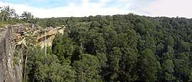 Tianjara Falls | |||||||||||||||
|
Tianjara Location in New South Wales | |||||||||||||||
| Coordinates | 35°08′12″S 150°18′10″E / 35.13667°S 150.30278°ECoordinates: 35°08′12″S 150°18′10″E / 35.13667°S 150.30278°E | ||||||||||||||
| Population | 0 (2016 census)[1] | ||||||||||||||
| Postcode(s) | 2622 | ||||||||||||||
| Location | |||||||||||||||
| LGA(s) | City of Shoalhaven | ||||||||||||||
| Region | South Coast | ||||||||||||||
| County | St Vincent | ||||||||||||||
| Parish | Tianjara | ||||||||||||||
| State electorate(s) | South Coast | ||||||||||||||
| Federal Division(s) | Gilmore | ||||||||||||||
| |||||||||||||||
Tianjara is a locality in the City of Shoalhaven in New South Wales, Australia.[2][3] It lies generally south of the Braidwood Road between Nowra and Nerriga. It is about 47 kilometres southwest of Nowra. Tianjara is fairly rugged sandstone country and largely consists of forest. Most of it lies within the Morton National Park or state forests. Tianjara Falls is located in its north just north of the Braidwood Road, but is usually dry except after significant rain. Mount Tianjara lies in its far south, with an elevation of 768 metres (2,520 ft) above sea level. At the 2016 census, it had a population of none.[1]
References
- 1 2 Australian Bureau of Statistics (27 June 2017). "Tianjara". 2016 Census QuickStats. Retrieved 5 May 2018.

- ↑ "Tianjara". Geographical Names Register (GNR) of NSW. Geographical Names Board of New South Wales. Retrieved 5 May 2018.
- ↑ "Tianjara". OpenStreetMap. Retrieved 5 May 2018.
| Nowra suburbs |
|
|---|---|
| Suburbs near Jervis Bay | |
| North of Shoalhaven River |
|
| South of Shoalhaven River |
|
| Sussex Inlet |
|
| Ulladulla |
|
| Far South |
|
Main Article: Local government areas of New South Wales | |
This article is issued from
Wikipedia.
The text is licensed under Creative Commons - Attribution - Sharealike.
Additional terms may apply for the media files.