Thungapuram
| Thungapuram Thungapuram/துங்கபுரம் Siru Mathurai, Kulothunga Chozhapuram | |
|---|---|
| Panchayat village | |
 | |
 Thungapuram Location in Tamil Nadu, India  Thungapuram Thungapuram (India) | |
| Coordinates: 11°11′N 79°06′E / 11.19°N 79.10°ECoordinates: 11°11′N 79°06′E / 11.19°N 79.10°E | |
| Country |
|
| State | Tamil Nadu |
| District | Perambalur |
| Languages | |
| • Official | Tamil |
| Time zone | UTC+5:30 (IST) |
| PIN | 621 716.[1] |
| Telephone code | 04328 |
| Vehicle registration | TN46, TN45 |
| Nearest city | Perambalur, Ariyalur, Thittakudi, Trichy. |
| Literacy | 72% |
| Climate | cool- hat-cool (Köppen) |
| Website |
wikimapia |
Thungapuram (Tunkapuram or Kulōttuŋkacōļapuram or Ciṛu Maturai) is a panchayat village of Perambalur district, Tamil Nadu, India. It was formerly in Tiruchirappalli district
History
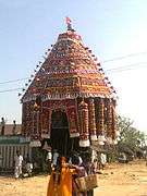
The historical name of Thungapuram is Kulothunga Chozhapuram. In the period of Kulothunga Chola kings this village was very famous for its festivals. Every year 12 festivals have conducted by this village, every month have one festival, The shape of this street was prised equivalent to madurai (square shape), hence it is called as Siru Madurai even it is too small compared to Madurai. Since there exists another village in the same name this village is renamed as Thungapuram by the postal department of India. In the period of Kulothunga Chola were made two important temples, the first one lord Siva "Sokkanathar Temple". Another one lord "Varatharaja Perumal Temple. These two temples are very old around 1000 years ago.
This area is famous for its cement industries in and around it. This is possible due to its immense limestone store which is the potential raw material for cement industries. In particular the Arasu cements, the Birla cements, the Sakthi cements, the Dalmia cements, the Tamil Nadu cements, etc. are situated in Near Thungapuram. It is also familiar for the Kaliyaperumaal Temple situated at 25 km from Thungapuram. The famous Gangaikonda Cholapuram is situated near to Thungapuram. This town is famous for the temple which was built by the King Rajendra Cholan of Chola Empire. The King Rajendra Cholan is the son of Rajaraja Cholan who built Brihadeeswarar Temple at Thanjavur. The temple is part of the UNESCO World Heritage Site known as the "Great Living Chola Temples"
Geography
Various streams run through the village, such as Yanaivari oodai (யானைவாரி ஓடை Yāņaivāri Ōţai).
The geographical location of Thungapuram is given below.
Places adjacent to Thungapuram | ||||||||||
|---|---|---|---|---|---|---|---|---|---|---|
| ||||||||||
Climate
Thungapuram has an average of 31 °C (88 °F) in the summer and an average of 20 °C (68 °F) in the winter.
| Summer | Winter | |
|---|---|---|
| Max. | 40 °C (104 °F) | 30 °C (86 °F) |
| Min. | 22 °C (72 °F) | 18 °C (64 °F) |
Politics
Before in 1995 Thungapuram have under Perambalur taluk and Tiruchirappalli district. After Composite Perambalur District came into existence after trifurcation of Tiruchirappalli district with effect from 30.09.1995 as per G.O MS.No 913 Revenue / Y3 dated 30.09.1995. Now its comes to under kunnam taluk in Perambalur district.
Thungapuram assembly constituency is part of Chidambaram (Lok Sabha constituency).[2]
Thungapuram panchayat constructed by Thungapuram South and Thungapuram North regions; The villages of Thungapuram and kiliyapattu are belongs to Thungapuram North region. The villages of kovilpalayam, thenur and anna nagar are belongs to Thungapuram South region.
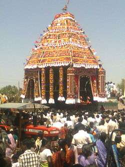
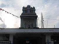
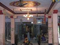
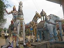
Historical Temples and Festivals
left|thumb|அருள்மிகு காரடையான் ஆலயம் Aruḷmiku Kāraţaiyāņ Ālayam
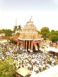
Thungapuram has many historical temples and places
- Aiyanar, Semmalaiyappar, Karadaiyan @ Karuppu Sami Temples: In this temple the Ayyannar Car festival (ஐயனார் திருத்தேர் Ayyaņār Tiruttēr) is a very most famous festival around this area, similar to the Thiruvarur car
- Load Vinnayaga temple
- Sokkanathar siva and Murugan temples
- Vinava Perumal temple
- Mariyamman temple
- Pappathiyamman temple
- Selliyamman temple
- Thuravupathi amman temple
- Vengaimallaian, karuppusami temples
- Kaman Temple (Rathi and Manmathan)
Agriculture and Major Crops
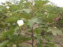
Rice and Sugar cane are grown as a major commercial crop. The pre-dominate soil in the district is red sanding with scattered packers of black soil. This village consists mainly of glade soil. The soil in the district is best suited for raising dry crops. Cotton also grown in many places.
- Rice (vast tracts)
- Sugarcane (vast tracts)
- Banana/plantain
- Coconut
- Cotton (vast tracts)
- Betel
- Corn
- Groundnut
Education
In Thungapuram panchayat have four schools:
- Panchayat Union Primary School, Thungapuram.
- It was established in the year of 1932 under the British Raj
- Government Higher Secondary School, Thungapuram .[3]
- In the year of 1960 the government of Tamil Nadu have started as a High School. Then it was promoted as a Higher Secondary School in 1990.
- Ramanuja High School, Thungapuram
- Panchayat Union Primary School, Kiliyapattu, Thungapuram (North)
- M G R welfare elementary School, Tholeeswarapuram, Thungapuram (South)
- Tamil Nadu Government, Most Backward Class Boys hostel,Thungapuram.
- Tamil Nadu Government,Most Backward Class Girl hostel,Thungapuram.
There are somany educated peoples are living in Thungapuram, i.e., Teachers, Professors, Scientists, Doctors, Engineers, Lawyers and so on...
Important Offices @ Thungapuram
- Head Post Office - Thungapuram-621 176
- The village have post office of the situating area and its postal index number 621 716.
- Panchayat Office
- District Village Library (திருவள்ளுவர் நூலகம் Tiruvaḷḷuvar Nūlakam)
- Indian Overseas Bank (IOB) - Thungapuram branch, Branch Code-1170, IFSC Code / MICR Code-IOBA0001170 [4] / NON-MICR.[5]
- Thungapuram Primary agricultural Co-operative Bank
- Tamil Nadu Electricity Bord(TNEB)and Power Station
- Tamil Nadu Government Primary Health Center (24 Hour's PHC) Around 35 villages covered in this PHC
- Mother-Child Care Center
- Tamil Nadu Government Veterinary Hospital
- Tamil Nadu civil consumer food & products
- Government Higher Secondary School
- Thungapuram Milk co-operative society TRD 1211 (Aavin)
- Birth and Death Registration office
Media and Communication
Leading Tamil, English languages newspapers are available in Thungapuram. English dailies such as, The New Indian Express, The Hindu [6] are available. Tamil daily Dinathanthi,Dinakaran, Dinamani and Maalaimalar are also available in Thungapuram. A station of All India Radio is located in nearby Trichy. In Thungapuram has several Local TV Channels and also several International TV Channels are available.
List of leading Mobile networks in Thungapuram:
| Network Name | Type | |
|---|---|---|
| Vodafone | GSM | WCDMA |
| Airtel | GSM | |
| Aircel | GSM | |
| BSNL | GSM | |
| Reliance | GSM |
How to reach Thungapuram
Thungapuram has located at:
- 21 km North from Ariyalur
- 85 km North-East from Trichy
- 275 km South from Chennai
- 13 km South from Thittakudi
- 37 km West from Jayankondam
- 37 km East from Perambalur
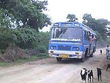
- Bus Route:
- Ariyalur-Thungapuram-Thittakudi. State Highway 143 - [SH143]
- Perambalur- Ariyalur (or) Maruthaiyan kovil-Thungapuram
- Jayankondam- Sendurai- Thungapuram
- Nearest Railway station: Ariyalur (18 km), Sendurai (12 km)
- Nearest Airport: Tiruchirapalli Airport or Trichy Airport (IATA: TRZ, ICAO: VOTR) (92 km)
- Tiruchirapalli International Airport is connected by air to Chennai,Mumbai, Kuala Lumpur, Singapore, Abudhabi, Dubai, Kuwait, sharjah and Colombo
Gallery


External links
References
- ↑ "Ariyalur - district sendurai - taluk ham let villages and postoffice" (PDF). Tamil Nadu. Government of Tamil Nadu. Archived from the original (PDF) on 2011-10-05.
- ↑ "List of Parliamentary and Assembly Constituencies" (PDF). Tamil Nadu. Election Commission of India. Archived from the original (PDF) on 2009-03-04. Retrieved 2008-10-11.
- ↑ "List of Government Higher Secondary School in Perambalur District". Tamil Nadu. Government of Tamil Nadu.
- ↑ "Indian Overseas Bank IFSC Code". Retrieved 2015-06-09.
- ↑ "Indian Overseas Bank-Display Branch Details". Indian Overseas Bank. External link in
|publisher=(help) - ↑ "The toppers in SSLC exams among the government schools in perambalur district". The Hindu. thehindu.com. 6 June 2012.