Three Shire Heads
| Three Shire Heads | |
|---|---|
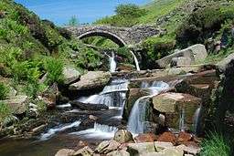 River Dane and packhorse bridge at Three Shire Heads | |
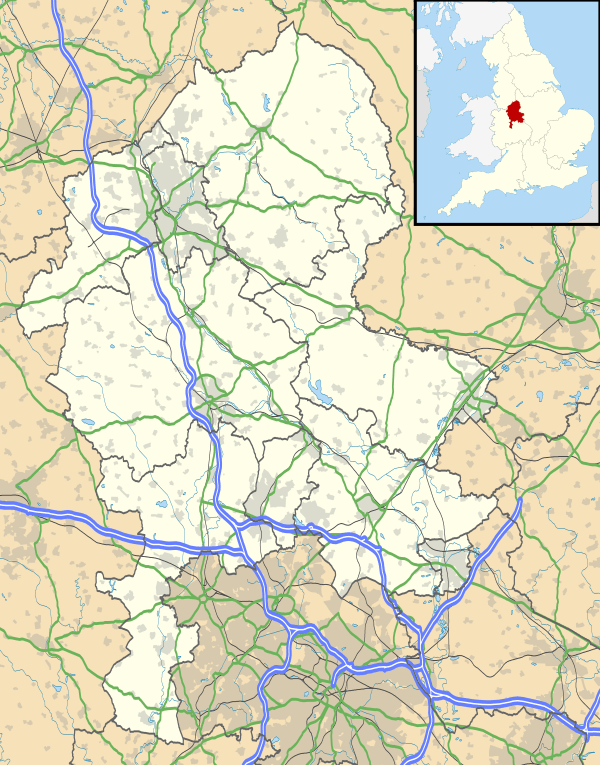 Three Shire Heads Three Shire Heads shown within Staffordshire | |
| OS grid reference | SK009685 |
| District | |
| Shire county | |
| Region | |
| Country | England |
| Sovereign state | United Kingdom |
| EU Parliament | West Midlands |
Three Shire Heads (also known as Three Shires Head) is the point on Axe Edge Moor where Cheshire, Derbyshire and Staffordshire meet, at UK grid reference SK009685, or 53°12′47″N 1°59′13″W / 53.213°N 1.987°W.
It is on the River Dane, which marks the Cheshire border in this area. On the east of the river, the border between Staffordshire and Derbyshire runs north-east for about a mile to Cheeks Hill, on the higher regions of Axe Edge Moor. From Cheeks Hill the border runs south then east to the head of the River Dove.[1]
The main landmark is a packhorse bridge. The bridge is Grade II-listed, and was probably constructed in the late 18th century.[2]
Access
The landmark is not directly accessible by motor vehicles, only on foot, bike or horseback and there is no parking provision nearby at all. Cars need to be left at least 3/4 mile from the site, where the tarmac roads run out.
Significance
In modern times, Three Shire Heads is a landmark on various walking routes in this part of the moorlands.[3][4][5][6]
The packhorse bridge and the waterfalls as the River Dane flows southwards are very picturesque,[7] and frequently feature on calendars.[8]
A report shows that this moorland area is of interest for its population of moths and butterflies.[9]
The presence of the packhorse bridge shows the importance of this route for traders from nearby Flash and Hollinsclough to Macclesfield. Silk was produced at Hollinsclough, and sent to the mills at Macclesfield.[10] Coal was mined from about 1600 on Axe Edge.[11]
Swimming
Three Shire Heads is well known for its free swimming, although the pools are cold.[12] The depth varies depending on the time of year: the main pool can be up to 7 feet deep.
References
- ↑ Ordnance Survey Landranger 1:50000 map, Sheet 119 (Buxton, Matlock and Dove Dale)
- ↑ Historic England. "Three Shire Heads bridge (1145883)". National Heritage List for England. Retrieved 24 August 2013.
- ↑ For example, see books by Graham Wilson.
- ↑ Christian Rambling Club report for May 2007, AGM at Gradbach Mill
- ↑ Poynton Ramblers, June 25
- ↑ Peak District Walking
- ↑ ePHOTOzine page including Three Shire Heads amongst photos for votes for ranking.
- ↑ One example is the W H Smith 2002 Peak District Calendar in which Three Shire Heads was both the scene for September and the cover picture for the whole calendar. (However, the photo shows foxgloves and was therefore probably taken in June or July.)
- ↑ Lepidoptera in Cheshire in 2002, A Report on the Micro-Moths, Butterflies and Macro-Moths of VC58, by S.H. Hind, S. McWilliam, B.T. Shaw, S. Farrell and A. Wander
- ↑ "Welcome". Hollinsclough. Retrieved 4 June 2017.
- ↑ Peak District View article on Axe Edge
- ↑ "Three Shires Head, Dane". Wild Swimming. Retrieved 12 February 2017.
External links
| Wikimedia Commons has media related to Three Shire Heads. |