Thorncliffe Park Raceway
_(cropped).jpg) | |
| Location |
Leaside, Ontario Canada |
|---|---|
| Date opened | July 21, 1917[1] |
| Date closed | August 12, 1953[1] |
| Course type | Flat Thoroughbred/Harness |
| Notable races |
Prince of Wales Stakes (1929–1952), My Dear Stakes (1941–1952), Clarendon Stakes (1926–1952) |
Thorncliffe Park Raceway was a racetrack in Leaside, Ontario, Canada that operated from 1917 until 1953. It was located east of Millwood Road, south of Eglinton Avenue East and north of the CPR railroad tracks. It was the first home of the Prince of Wales Stakes. The name is retained today in the name of the current Thorncliffe Park neighbourhood in Toronto.
History
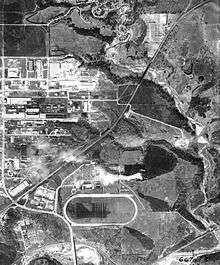
The site of Thorncliffe Park was a farm owned by Robert T. Davies, the wealthy founder of the Dominion Brewing Company. An avid participant in horse racing, under the banner of Thorncliffe Stable, he raced both thoroughbred and standardbred horses. After Davies' death in 1916 his estate sold the property to a group of investors from Baltimore, Maryland who built a horse racetrack. The track had a simple but small grandstand structure (and covered area) on the northside of the track, stables to the northeast and more stables and parking at the northwest side. Home to Thoroughbred horse racing, the track also revitalized harness racing in Toronto following its opening on July 21, 1917. Among its thoroughbred races, the track notably hosted the Prince of Wales Stakes, the My Dear Stakes, and the Clarendon Cup. The track operated until 1952 when it was sold to the Ontario Jockey Club who shut down thoroughbred racing on June 23, 1952 and harness racing on the site on August 12, 1953. The property was sold to a newly formed real estate development company. The raceway was demolished in 1954.[2]
Today, the old racetrack site is commemorated by two streets named Grandstand Place and Milepost Place and the number of residential and commercial buildings that took on racetrack stable names like Churchill, Maple Glen and Willow Glen. Leaside Park and a wooded area cover the area to the south of the original racetrack.
References
- 1 2 "The Way We Were". The Canadian Horse Racing Hall of Fame. Archived from the original on 2011-07-12. Retrieved 2010-03-23.
- ↑ Kennedy, Scott (February 18, 2017). Don Mills: From Forests and Farms to Forces of Change. Dundum. ISBN 1459736842. Retrieved April 11, 2017.