Thirtymile, Oregon
| Thirtymile, Oregon | |
|---|---|
| Unincorporated community | |
 Thirtymile  Thirtymile | |
| Coordinates: 45°10′09″N 120°09′31″W / 45.16917°N 120.15861°WCoordinates: 45°10′09″N 120°09′31″W / 45.16917°N 120.15861°W | |
| Country | United States |
| State | Oregon |
| County | Gilliam |
| Elevation | 2,113 ft (644 m) |
| Time zone | UTC-8 (Pacific (PST)) |
| • Summer (DST) | UTC-7 (PDT) |
| GNIS feature ID | 1136824[1] |
| Coordinates and elevation from the Geographic Names Information System (GNIS)[1] | |
Thirtymile is an unincorporated community in Gilliam County, Oregon, United States.[1] It lies south of Condon and east of Oregon Route 19 along Thirtymile Creek, a tributary of the John Day River.[2][3]
References
- 1 2 3 "Thirtymile". Geographic Names Information System. United States Geological Survey. November 28, 1980. Retrieved October 31, 2016.
- ↑ "Thirtymile". ACME Labs. Retrieved October 31, 2016 – via ACME Mapper.
- ↑ Oregon Atlas & Gazetteer (7th ed.). Yarmouth, Maine: DeLorme. 2008. pp. 72–73. ISBN 978-0-89933-347-2.
Municipalities and communities of Gilliam County, Oregon, United States | ||
|---|---|---|
| Cities | 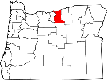 | |
| Unincorporated communities | ||
| Ghost town | ||
| Indian reservation | ||
| Footnotes | ‡This populated place also has portions in an adjacent county or counties | |
This article is issued from
Wikipedia.
The text is licensed under Creative Commons - Attribution - Sharealike.
Additional terms may apply for the media files.