The Historical Atlas of China
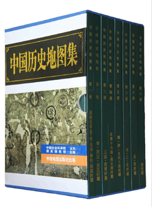 The Historical Atlas of China, printed in 1996 | |
| Editor | Tan Qixiang |
|---|---|
| Country | China |
| Language | Chinese |
| Genre | Atlas, History |
| Publisher | China Cartographic Publishing House |
Publication date | 1982–88 |
| Media type | |
The Historical Atlas of China (traditional Chinese: 中國歷史地圖集; simplified Chinese: 中国历史地图集; pinyin: Zhōngguó lìshǐ dìtú jí) is an 8-volume work published in Beijing between 1982 and 1988, edited by Tan Qixiang. It contains 304 maps and 70,000 placenames in total. The Concise Historical Atlas of China (Chinese: 简明中国歷史地图集; pinyin: Jiǎnmíng Zhōngguó lìshǐ dìtú jí) was published in 1991.
Contents
The atlas consists of 8 volumes:
- Archaeological findings, Xia, Shang dynasties and Zhou dynasty (Western Zhou, Spring and Autumn period and Warring States period)
- Qin dynasty, Western and Eastern Han dynasties
- Three Kingdoms and Western Jin dynasty
- Eastern Jin dynasty, Sixteen Kingdoms and Southern and Northern Dynasties
- Sui dynasty, Tang dynasty and Five Dynasties and Ten Kingdoms period
- Song dynasty, Liao dynasty and Jin Empire
- Yuan dynasty and Ming dynasty
- Qing dynasty
On each map, ancient places and water features are shown in black and blue respectively, superimposed on modern features, borders and claims, shown in brown. All country-wide maps, from Paleolithic onward, include an inset showing the Nine-Dash Line in the South China Sea. Placenames are given in simplified characters, though an edition of the atlas published in Hong Kong uses traditional characters.[1]
Reception
The Atlas is considered the most authoritative compendium of ancient place names and administrative boundaries, and a tremendous improvement on its predecessor, Yang Shoujing's Lidai yudi tu (Yangtu, "Yang's atlas", 1906–1911).[2][3] However, more controversial has been Tan's historical conception:[4]
When the Qing dynasty had succeeded in unifying the country by the 1750s [...] the historical development of several millennia towards establishing China's territorial extent had been completed. All those nationalities which have lived within that territory are historically Chinese nationalities, and all the political entities established by these nationalities are historical parts of China.
— Tan Qixiang, "General Compiling Principles", The Historical Atlas of China
This vision has been criticized as anachronistically projecting 20th-century minority policy and border claims into the distant past, resulting in a distorted view of the history of peripheral areas, portraying their incorporation into China as an inevitable organic process, rather than the result of conquest.[3] Similarly, early states are often given overly precise and extensive outer borders, often based on contentious claims.[5][6] In his afterword to volume 8, written in 1987, Tan regretted expanding the borders of Chinese empires to encompass jimi and tusi regimes.[7]
Related images
These Wikipedia maps are drawn after The Historical Atlas of China (1982).
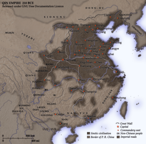 Qin empire (210 BCE)
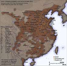 Han commanderies and kingdoms (2 CE)
 Han civilisation (2 CE)
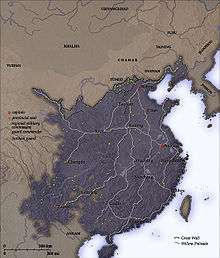 Ming dynasty (1580)
See also
- General History of Chinese Administrative Divisions, a 13-volume series envisioned by Tan Qixiang and completed by his students
References
- ↑ Wilkinson (2012), p. 245.
- ↑ McColl (1992), p. 362.
- 1 2 Wilkinson (2012), pp. 245–246.
- ↑ Kallio (2011), p. 22.
- ↑ Terrill (2003), p. 197.
- ↑ Black (2000), pp. 193–194.
- ↑ Wilkinson (2012), p. 246.
Works cited
- Black, Jeremy (2000), Maps and History: Constructing Images of the Past, Yale University Press, ISBN 978-0-300-08693-5.
- Kallio, Jyrki (2011), Tradition in Chinese politics: The Party-state's reinvention of the past and the critical response from public intellectuals, Finnish Institute of International Affairs, ISBN 978-951-769-294-6.
- McColl, R.W. (1992), "The Historical Atlas of China", The Professional Geographer, 44 (3): 362–363, doi:10.1111/j.0033-0124.1992.00349.x.
- Terrill, Ross (2003), The New Chinese Empire, UNSW Press, ISBN 978-0-86840-758-6.
- Wilkinson, Endymion (2012), Chinese History: A New Manual, Cambridge, MA: Harvard-Yenching Institute; Harvard University Asia Center, ISBN 978-0-674-06715-8.
External links
- Chinese Civilization in Time and Space: a project at Academia Sinica, Taiwan, based on a vectorization of Tan's atlas.