The Friars (Tasmania)
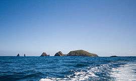
The Friars are four steep dolerite rocks, with a combined area of about 17 ha (42 acres), in south-eastern Australia. They are part of the Actaeon Island Group, lying close to the south-eastern coast of Tasmania, at the southern entrance to the D'Entrecasteaux Channel between Bruny Island and the mainland. They form part of South Bruny National Park.[1][2]
The group was named The Fryars by Tobias Furneaux in Adventure in March 1773.[3][4][5]
Fauna
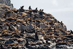
Recorded breeding seabird species are the little penguin, short-tailed shearwater, fairy prion and common diving-petrel. The metallic skink is present. Australian fur seals, and possibly New Zealand fur seals, use the rocks as a regular haul-out site.[1]
References
- 1 2 Brothers, Nigel; Pemberton, David; Pryor, Helen; & Halley, Vanessa. (2001). Tasmania’s Offshore Islands: seabirds and other natural features. Tasmanian Museum and Art Gallery: Hobart. ISBN 0-7246-4816-X
- ↑ Small Southern Islands Conservation Management Statement 2002 (PDF), Tasmania Parks and Wildlife Service, 2002, archived from the original (PDF) on 2006-08-22, retrieved 2006-07-20
- ↑ The Early History of Tasmania.By R.W.Giblin 1928, page 47
- ↑ Sprod, Dan (2005). "Furneaux, Tobias (1735 - 1781)". Australian Dictionary of Biography. Canberra: Australian National University. Retrieved 2008-05-05.
- ↑ Cook, James; Furneaux, Tobias (1777), A voyage towards the South Pole, and round the world : performed in His Majesty's ships the Resolution and Adventure, in the years 1772, 1773, 1774, and 1775, Printed for W. Strahan and T. Cadell , Chapter VII, entry for March 1773
Coordinates: 43°31′S 147°17′E / 43.517°S 147.283°E
Southern region of Tasmania, Australia | |||||
|---|---|---|---|---|---|
| City Other settlements | |||||
| Governance | |||||
| Mountains | |||||
| Protected areas, parks and reserves | |||||
| Rivers | |||||
| Harbours, bays, inlets and estuaries | |||||
| Coastal features | |||||
| Transport | |||||
| Landmarks |
| ||||
| Islands | |||||
| Books and newspapers | |||||
| Flora, fauna, and fishlife | |||||
| Bioregions | |||||
| Indigenous heritage | |||||
| Other | |||||
| |||||