Tevairoa
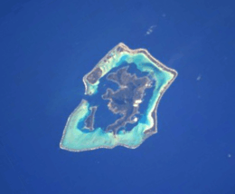 The Bora Bora Group. | |
| Geography | |
|---|---|
| Location | Pacific Ocean |
| Coordinates | Coordinates: 16°28′16″S 151°46′41″W / 16.471°S 151.778°W |
| Archipelago | Society Islands |
| Area | 2.363 km2 (0.912 sq mi) |
| Highest elevation | 20 m (70 ft) |
| Highest point | Tevairoa hill |
| Administration | |
|
France | |
| Commune | Bora Bora Commune |
| Island Group | Bora Bora |
| Largest settlement | Tevairoa (pop. 20 inhabitants) |
| Demographics | |
| Population | 20 (2016) |
| Pop. density | 8.5 /km2 (22 /sq mi) |
Motu Tevairoa is a 2.363 km2 (0.9 sq mi) island in the Bora Bora Islands Group, within the Society Islands of French Polynesia. It is the located between Haapiti Rahi, and Ahuna.
Geography
Motu Tevairoa is the second largest island in the Bora Bora group.
Administration
The island is part of Bora Bora Commune.
Demographics
Tevairoa, the main village of the island, is on the south corner.
Tourism
The Island hosts the Pearl Beach Resort.[1]
Transportation
After arriving in Fa'a'ā International Airport, an Air Tahiti inter-island flight (50 minutes) will bring you to Bora Bora Airport.
You will need to board the airline’s catamaran shuttle to Vaitape, where you can hire a boat to Toopua. Conrad Hilton resort operates a helipad on the island.
References
- ↑ "Pearl Beach Resort". Retrieved July 28, 2017.
External links
This article is issued from
Wikipedia.
The text is licensed under Creative Commons - Attribution - Sharealike.
Additional terms may apply for the media files.