Bora Bora Commune
| Bora-Bora | |
|---|---|
 Location of the commune (in red) within the Leeward Islands | |
| Coordinates: 16°29′40″S 151°44′11″W / 16.4944°S 151.7364°WCoordinates: 16°29′40″S 151°44′11″W / 16.4944°S 151.7364°W | |
| Country | France |
| Overseas collectivity | French Polynesia |
| Government | |
| • Mayor | Gaston Tong Sang |
| Area | 41.55 km2 (16.04 sq mi) |
| Population (2016)1 | 9,692 |
| • Density | 230/km2 (600/sq mi) |
| INSEE/Postal code | 98714 /98730 |
| Elevation | 0–727 m (0–2,385 ft) |
| 1 Population without double counting: residents of multiple communes (e.g., students and military personnel) only counted once. | |
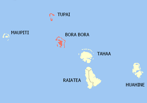
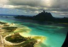
Bora-Bora is a commune of French Polynesia, an overseas territory of France in the Pacific Ocean. The commune is in the administrative subdivision of the Leeward Islands.
The commune of Bora-Bora is made up of the island of Bora Bora proper with its surrounding islets emerging from the coral reef (30.55 km²/11.3 sq. miles in total) and of the atoll of Tupai (11 km2 (4.2 sq mi)), located 20 kilometres (12 mi) north of Bora Bora. The atoll of Tupai has no permanent population apart from some seasonal workers in the coconut plantations.
The surrounding islets include Motu Tapu, Motu Ahuna, Tevairoa, Motu Tane, Motu Mute, Motu Tufari, Motu Tehotu, Motu Pitiaau, Sofitel Motu, Motu Toopua, and Toopuaiti.
Administration
The commune is in the administrative subdivision of the Leeward Islands and consists of the following associated communes:
- Anau
- Faanui
- Vaitape
The administrative center of the commune is the settlement of Vaitape, on the island of Bora Bora.
President of French Polynesia Édouard Fritch is the current mayor of Bora Bora in addition to being the President.[1]
References
- ↑ "President of French Polynesia steps down". The Australian. 8 February 2009. Retrieved 12 February 2009.