Teuri Island
| Native name: 天売島, Teuri-tō | |
|---|---|
 Teuri Island, Haboro, Hokkaidō, Japan | |
| Geography | |
| Location | East Asia |
| Coordinates | 44°25′N 141°18′E / 44.417°N 141.300°ECoordinates: 44°25′N 141°18′E / 44.417°N 141.300°E |
| Archipelago | Japanese archipelago |
| Area | 5.5 km2 (2.1 sq mi) |
| Coastline | 12 km (7.5 mi) |
| Highest elevation | 184.5 m (605.3 ft) |
| Highest point | Southwest Teuri Island |
| Administration | |
|
Japan | |
| Prefecture | Hokkaido |
| Subprefecture | Rumoi Subprefecture |
| District | Tomamae District |
| Town | Haboro |
| Demographics | |
| Population | 366 (2010) |
| Pop. density | 66.5 /km2 (172.2 /sq mi) |
| Ethnic groups | Ainu, Japanese |
Teuri Island (天売島 Teuri-tō) is an island floating in the Sea of Japan 30 km west of Haboro port in Haboro, Tomamae District, in the Rumoi Subprefecture in Hokkaido. The Island, along with neighboring Yagishiri island on its east side, belongs to the town of Haboro in Rumoi Subprefecture. The island has an area of 5.5 square kilometers (2.1 sq mi), with 12 km of coastline, and the population is 317 people as of March, Heisei 20 (2008). It is said that the name of the island comes from the Ainu language, where the name could either be interpreted as “fish back” or “leg.”
Overview[1]
The island’s cliff-lined northwest coast serves as a breeding ground for common guillemot, Rhinoceros Auklet, Spectacled Guillemot, Japanese cormorant, and slaty-backed gull. For this reason, on August 8, 1939, Teuri island was appointed as a natural monument and now is known as "Teuri Island seabird breeding ground"[2]. On March 31, 1982, Teuri island was designated part of the Wildlife Protection Areas in Japan. In Haboro town, in order to protect the wildlife such as seabirds, measures were taken since April 2012 to control the increase of the local population of stray cats.
Currently, the Terui island is an island covered with green, but since the Meiji era, most of the forest in the island was lost caused by the settler and the often occurrence of the forest fires. After the World War II, Hokkaido began a land restoration project in order to afforestation the island from the previous damage. Under an harsh natural environment on the island, the land restoration project[3] underwent some difficulty, but the result is finally seen on August 1, 1990. The island is now designated as part of the Shokanbetsu-Teuri-Yagishiri Quasi-National Park for one of the must sightseeing place in Japan.[4]
Transport
Teuri port[5]
- Haboro Enkai Ferry
- Haboro-Yagishiri-Teuri(High-speed craft take about one hour and with ferry one hour and thirty-five minutes)
- Yagishiri-Teuri(High-speed craft take about fifteen minutes and with ferry twenty-five minutes)
Hokkaido Prefectural Road Route 548 is the general road for the Teuri island that made into an anti 6 shape.
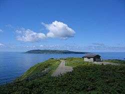
Landmark[6]
- Kannonzaki Observatory
- Akaiwa Observatory
- Seabird Observatory
- Chidorigaura
References
- ↑ "History of Teuri Island".
- ↑ "海鳥的樂園,天賣島上世界最大規模角嘴海雀繁殖地! | 北海道Likers". Retrieved 2018-10-06.
- ↑ "天売協定締結 | 留萌振興局森林室森林室". www.rumoi.pref.hokkaido.lg.jp (in Japanese). Retrieved 2018-10-07.
- ↑ 羽幌町役場. "まちのあゆみ|羽幌町の紹介|羽幌町". www.town.haboro.lg.jp (in Japanese). Retrieved 2018-10-07.
- ↑ Kodera, Atsushi (2015-07-22). "Island offers free ferry trips in novel seabird rescue project". The Japan Times Online. ISSN 0447-5763. Retrieved 2018-10-06.
- ↑ "Haboro travel-brochure" (PDF).