Téglás
| Téglás | ||
|---|---|---|
| Town | ||
| ||
 Téglás | ||
| Coordinates: 47°43′N 21°41′E / 47.717°N 21.683°E | ||
| Country |
| |
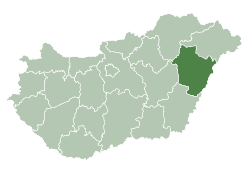
| County | Hajdú-Bihar | |
| District | Hajdúhadház | |
| Date of Establishment of Seal and Coat of Arms | 1706 | |
| Area | ||
| • Total | 38.33 km2 (14.80 sq mi) | |
| Population (2015) | ||
| • Total | 6,406[1] | |
| • Density | 167.1/km2 (433/sq mi) | |
| Time zone | UTC+1 (CET) | |
| • Summer (DST) | UTC+2 (CEST) | |
| Postal code | 4243 | |
| Area code | (+36) 52 | |
| Website |
www | |

Téglás is a town in Hajdú-Bihar county, in the Northern Great Plain region of eastern Hungary.
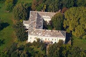
Aerialphotography of Téglás
Geography
It covers an area of 38.33 km2 (15 sq mi) and has a population of 6406 people (2015).[1] Téglás also is accessible to Debrecen to the south and Nyíregyháza to the north. As well as those two locations, you could head west towards Balkány.[2]
Sports
Téglás has a soccer team called Téglas VSE.[3]
International relations
Twin towns — Sister cities
Téglás is twinned with:


References
- 1 2 Gazetteer of Hungary, 1st January 2015. Hungarian Central Statistical Office. 03/09/2015
- ↑ "Where is Téglás, Hungary located? Distance Calculator". www.entfernungsrechner.net. Retrieved 2016-07-13.
- ↑ "Téglási Városi Sport Club". teglasvse.hu. Retrieved 2016-07-13.
External links
| Wikimedia Commons has media related to Téglás. |
- Official website in Hungarian
| Towns (2) |
| |
|---|---|---|
| Village (1) | ||
| City with county rights |
|   |
|---|---|---|
| Towns | ||
| Large villages | ||
| Villages |
| |
| Other topics |
| |
Coordinates: 47°43′N 21°41′E / 47.717°N 21.683°E
This article is issued from
Wikipedia.
The text is licensed under Creative Commons - Attribution - Sharealike.
Additional terms may apply for the media files.