Testa Grigia (Aosta Valley)
| Testa Grigia / Tête grise | |
|---|---|
|
Groabhopt (Walser German) Graukopf (German) | |
 Testa Grigia | |
| Highest point | |
| Elevation | 3,315 m (10,876 ft) |
| Prominence | 643 m (2,110 ft) [1] |
| Coordinates | 45°49′51″N 7°47′11″E / 45.830901°N 7.786424°ECoordinates: 45°49′51″N 7°47′11″E / 45.830901°N 7.786424°E |
| Geography | |
 Testa Grigia / Tête grise Location in the Alps | |
| Location | Aosta Valley, Italy |
| Parent range | Pennine Alps |
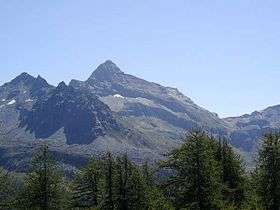
Testa Grigia (French : Tête grise, lit. "grey head") (3,315m) is a mountain on the Italian side of the Monte Rosa Massif in the Pennine Alps. It is the highest mountain of the ridge that separates the Lys valley (Gressoney-La-Trinité) from the Ayas Valley, in Aosta Valley.
Ascent
It is usually climbed from the Gressoney side, where the climb presents no technical difficulties, as the route is assisted by a fixed rope. The summit offers a fine balcony view of Monte Rosa and the Matterhorn.[2]
References
- ↑ "Testa Grigia - Peakbagger". peakbagger.com. Retrieved 17 February 2015.
- ↑ "Testa Grigia - summitpost". summitpost.org. Retrieved 17 February 2015.
This article is issued from
Wikipedia.
The text is licensed under Creative Commons - Attribution - Sharealike.
Additional terms may apply for the media files.