Lys (Dora Baltea)
| Lys | |
|---|---|
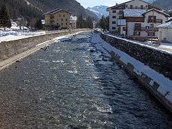 The Lys at Gressoney-Saint-Jean | |
| Country | Italy |
| Physical characteristics | |
| Main source |
Monte Rosa 2,500 m (8,200 ft) |
| River mouth | Dora Baltea |
| Length | 40 km (25 mi) |
The Lys (Walser German: Liisu or Lyesu) is a small 40 kilometres (25 mi) river (classified as a torrente) which flows from the Lys Glacier on the south side of the Monte Rosa massif, at the foot of Vincent Pyramid, elevation 4,215 metres (13,829 ft), and runs through the Val de Gressoney, flanked by a road, before converging with the Dora Baltea (fr. Doire baltée) as a right tributary at Pont-Saint-Martin.
Its left-side tributaries are Avant-Cir, Glassit, Loo, Mos, Niel, Pacoulla, and Tourrison. From the right it receives: Rû de Nantay, Stolen and Valbona.
This article is issued from
Wikipedia.
The text is licensed under Creative Commons - Attribution - Sharealike.
Additional terms may apply for the media files.