Angrignon station
Angrignon | |||||||||||
|---|---|---|---|---|---|---|---|---|---|---|---|
 | |||||||||||
| Location |
3500, boulevard des Trinitaires, Montreal Quebec, Canada | ||||||||||
| Coordinates | 45°26′46″N 73°36′13″W / 45.44611°N 73.60361°WCoordinates: 45°26′46″N 73°36′13″W / 45.44611°N 73.60361°W | ||||||||||
| Operated by | Société de transport de Montréal | ||||||||||
| Connections | See Terminus Angrignon | ||||||||||
| Construction | |||||||||||
| Depth | 4.3 metres (14 feet 1 inch), shallowest, tie with Longueuil–Université-de-Sherbrooke) | ||||||||||
| Architect | Jean-Louis Beaulieu | ||||||||||
| History | |||||||||||
| Opened | 3 September 1978 | ||||||||||
| Traffic | |||||||||||
| Passengers | 4,730,525 entrances in 2013, 16th of 68 | ||||||||||
| Services | |||||||||||
| |||||||||||
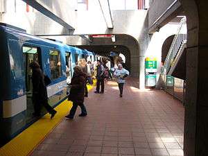
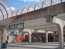
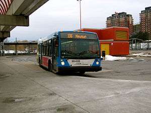
Angrignon station is a Montreal Metro station in Le Sud-Ouest borough of Montreal, Quebec. It is operated by the Société de transport de Montréal (STM) and serves the Green Line.[1] The station includes a large bus terminus for buses to southwest Montreal, the West Island (Dorval), and South Western Quebec.
Architecture
Angrignon station is built with windows encasing the tracks and side platforms, which creates a very light and airy environment. Jean-Louis Beaulieu received an award from the Ordre des architectes du Québec[2] for the design of the station.
The station is equipped with the MétroVision information screens which displays news, commercials, and the time till the next train.
Origin of the name
Jean-Baptiste Arthur Angrignon was alderman of the district of Saint-Paul and a member of the Executive Committee of the city of Montreal. He oversaw the development of what is now Parc Angrignon on what was land that belonged to the Crawford family. The area was named after him in 1927.
Nearby points of interest
- Carrefour Angrignon shopping centre
- Parc Angrignon
- Ferme Angrignon zoo
Terminus Angrignon
Terminus Angrignon | |
|---|---|
 | |
| Location | 3500, boul. des Trinitaires[3] |
| Coordinates | 45°26′47″N 73°36′15″W / 45.44639°N 73.60417°W |
| Operated by | RTM |
| Line(s) | |
| Construction | |
| Parking | 733 park and ride spaces[3] |
| Bicycle facilities | 90 place racks[3] |
| Other information | |
| Website | Terminus Angrignon |
| Traffic | |
| Passengers (2016[4]) | 6,168,600 |
This large bus terminal is a facility of the Réseau de transport métropolitain (RTM). One area has bus bays assigned to suburban commuter buses from southwestern Quebec, with three bus loops being used by the STM[5] for routes that service southwest Montreal and the West Island. They also operate an adjoining park and ride lot.
Connecting bus routes
| Société de transport de Montréal | |||
|---|---|---|---|
| Route | Service Times | Map | Schedule |
| All-day | Map | Schedule | |
| All-day | Map | Schedule | |
| All-day, Weekends before 12:00AM | Map | Schedule | |
| All-day | Map | Schedule | |
| All-Day before 11:00PM | Map | Schedule | |
| All-day | Map | Schedule | |
| All-day | Map | Schedule | |
| All-day | Map | Schedule | |
| Overnight | Map | Schedule | |
| |
Rush Hours, Morning Arrivals and Afternoon Departures | Map | Schedule |
| All-day Weekdays | Map | Schedule | |
| RTM Roussillon (CITROUS) | |||
| Route | Service Times | Map | Schedule |
| 200 Terminus Angrignon - CÉGEP André-Laurendeau - Autoparc Georges-Gagné | Rush Hour | Map | Schedule |
| RTM Sud-Ouest (CITSO) | |||
| Route | Service Times | Map | Schedule |
| 1 Valleyfield - Angrignon | All day weekdays | N/A | PDF Schedule |
| 21 Châteauguay - Angrignon | Rush hour | N/A | PDF Schedule |
| 22 Châteauguay - Angrignon | Rush hour | N/A | PDF Schedule |
| 23 Châteauguay - Angrignon | Rush hour | N/A | PDF Schedule |
| 24 Châteauguay - Angrignon | Rush hour | N/A | PDF Schedule |
| 25 Châteauguay - Angrignon | Rush hour | N/A | PDF Schedule |
| 26 Châteauguay - Angrignon | Morning rush hour | N/A | PDF Schedule |
| 31 Châteauguay - Angrignon | All-day | N/A | PDF Weekday Schedule |
| 32 Châteauguay - Angrignon | All-day | N/A | PDF Weekday Schedule |
| 98 Kahnawake - Angrignon | Rush hour and weekday evenings | N/A | PDF Schedule |
| RTM Haut-Saint-Laurent (CITHSL) | |||
| Route | Service Times | Map | Schedule |
| 1 Huntingdon - Montréal | All-day | Map | PDF Schedule |
See also
References
- ↑ Angrignon Metro Station
- ↑ Ordre des architectes du Québec
- 1 2 3 RTM Terminus Angrignon page
- ↑ Ridership from Rapport annuel 2016 (PDF). rtm.qc.ca (Report). Montreal: Réseau de transport métropolitain [Metropolitan Transportation Network]. ISBN 978-2-550-75552-4.
- ↑ Neighbourhood Map
External links
| Wikimedia Commons has media related to Angrignon (Montreal Metro). |
| Existing lines |  | |
|---|---|---|
| Proposed lines | ||
| Cancelled lines | ||
| Rolling stock | ||