Tennessee State Route 62
| ||||
|---|---|---|---|---|
| Route information | ||||
| Maintained by TDOT | ||||
| Length | 89.93 mi (144.73 km) | |||
| Major junctions | ||||
| West end |
| |||
|
| ||||
| East end |
| |||
| Location | ||||
| Counties | Putnam, Fentress, Morgan, Roane, Anderson, Knox | |||
| Highway system | ||||
| ||||


State Route 62 (SR 62) is a west-to-east highway in the U.S. state of Tennessee that is 83 miles (134 km) long. It is designated as a primary route except for the short segment between SR 169 and its eastern terminus, which is secondary.
State Route 62 begins in Putnam County at State Route 84; it ends in Knox County at State Route 71.
Route Description
Putnam County

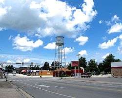
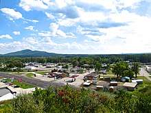
SR 62 begins in Putnam County in downtown Monterey as a primary highway at an intersection with SR 84 and SR 164. It then heads east (as East Commercial Ave.) through downtown before leaving Monterey (as Clarkrange Hwy.) as a 2-lane highway to parallel I-40 for a short distance before going through forested areas and the community of Muddy Pond before crossing into Fentress County.
Fentress County
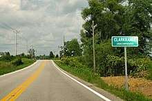
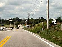
SR 62 then immediately enters farmland and goes down a fertile valley before entering Clarkrange and junctioning with US 127/SR 28. It then leaves Clarkrange (as Deer Lodge Hwy.) and continues east through farmland and crosses into Morgan County.
Morgan County
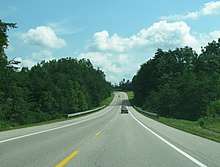
In Morgan County, SR 62 enters the Eastern Time Zone, leaving farmland and becoming very curvy (and becoming Nashville Highway), heading east through the mountains of the Cumberland Plateau. It then intersects the southern end of SR 329 south of Deer Lodge, before continuing east to intersect with SR 298. SR 62 continues eastward and goes through Lancing and becomes even curvier, before coming to an intersection with US 27/SR 29 (Morgan County Highway) north of Wartburg. It becomes concurrent with US 27/SR 29 and widens into a 4-lane highway before entering Wartburg. They then pass just east of downtown before SR 62 separates from US 27/SR 29 and continues southeast (as Knoxville Hwy.) as a 4-lane and then exits Wartburg. It then continues southeast and narrows to a 2-lane before entering Joyner. SR 62 continues through Joyner, which is mainly farmland, and then junctions with SR 116 west of Petros before entering Stephens. It goes through Stephens and then goes through a short mountain pass (locally known as Stephens Mountain) before entering Coalfield. It goes through Coalfield and then enters Oliver Springs and crosses into Roane County.
Roane County
It then has an intersection with SR 61 (Tri County Blvd./Harvey H. Hannah Memorial Highway) and SR 330 and becomes concurrent with SR 61. It then bypasses downtown to the north and east as a 4-lane and enters Anderson County.
Anderson County
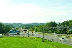
It continues through Oliver Springs and then Separates from SR 61 and enters Oak Ridge (as Illinois Ave). In Oak Ridge, SR 62 has a junction with SR 95. It continues through Oak Ridge and widens to a 6-lane and goes through a major business district, passing by the Oak Ridge City Center (Mall), before downgrading to a 4-lane at an interchange with Centrifuge way. It continues to an interchange with Bethel Valley Rd., which provides access to the Y-12 National Security Complex. It then has an interchange with SR 170 before leaving Oak Ridge and crossing the Clinch River, crossing into Knox County and entering Solway.
Knox County
SR 62 goes through Solway (as Oak Ridge Hwy.) and has partial interchange with SR 162 (Pellisippi Parkway) before leaving Solway and narrowing to a 2-lane. It then enters Karns and junctions with SR 131. It then leaves Karns and enters Knoxville, widening to a 4-lane (and becoming Western Ave.). SR 62 continues through North Knoxville before widening to a 6-lane and has an interchange with I-640/I-75. It then narrows to a 2-lane for short distance before widening back out to a 4-lane and intersects SR 169. SR 62 then turns secondary and has an interchange with I-40/I-275 before entering downtown and ending at an intersection with US 11/US 70/US 441/SR 33/SR 1/SR 71.
Junction list
| County | Location | mi | km | Destinations | Notes |
|---|---|---|---|---|---|
| Putnam | Monterey | Western terminus; SR 62 begins as a primary route | |||
| Southern terminus of SR 164 | |||||
| Fentress | Clarkrange | ||||
| Morgan | | Southern terminus of SR 329 | |||
| | Northern terminus of SR 298 | ||||
| Lancing | Western end of US 27/SR 29 concurrency | ||||
| Wartburg | North Kingston Street – Downtown Wartburg, Obed Wild and Scenic River National Park Service Visitor Center, Justin P. Wilson Cumberland Trail State Park | ||||
| Water Tank Hill Road South – Downtown Wartburg | |||||
| Eastern end of US 27/SR 29 concurrency | |||||
| Joyner | Southern terminus of SR 116 | ||||
| Roane | Oliver Springs | Eastern end of SR 61 concurrency; Southern terminus of SR 330 | |||
| Anderson | Downtown Oliver Springs To | Interchange; Westbound exit and eastbound entrance | |||
| Eastern end of SR 61 concurrency | |||||
| Oak Ridge | |||||
| Centrifuge Way | Interchange | ||||
| Bethel Valley Road – Oak Ridge National Laboratory, Y-12 National Security Complex | Interchange | ||||
| Western terminus of SR 170; Interchange | |||||
| Knox | Solway | Interchange; Northern terminus of SR 162; No Access to SR 162 from westbound 62 | |||
| Karns | |||||
| Knoxville | Ed Shouse Road To | ||||
| I-640, exit 1 | |||||
| Eastern terminus of SR 169; SR 62 changes to a secondary route | |||||
| Ramp to I-275 North and I-40 East | |||||
| Eastern terminus of SR 62; SR 62 ends as a secondary route | |||||
1.000 mi = 1.609 km; 1.000 km = 0.621 mi
| |||||
Counties traversed (west to east)
| Counties traversed by State Route 62 | ||
|---|---|---|
| County | miles | kilometers |
| Putnam | 10.4 | 16.8 |
| Fentress | 12.7 | 20.5 |
| Morgan | 36.0 | 58.0 |
| Roane | 0.1 | 0.2 |
| Anderson | 7.2 | 11.6 |
| Knox | 16.5 | 26.5 |
See also
References
- Tennessee Department of Transportation (24 January 2003). "State Highway and Interstate List 2003".
External links
| Wikimedia Commons has media related to Tennessee State Route 62. |