Tempe Wick Road–Washington Corners Historic District
|
Tempe Wick Road–Washington Corners Historic District | |
 | |
   | |
| Location |
Corey Lane, Cemetery Road, Tempe Wick, Kennaday, Leddell, and Jockey Hollow Road Harding Mendham Township Morris County, New Jersey |
|---|---|
| Coordinates | 40°45′56″N 74°33′30″W / 40.76556°N 74.55833°WCoordinates: 40°45′56″N 74°33′30″W / 40.76556°N 74.55833°W |
| Area | 237.2 acres (96.0 ha) |
| Architect | Multiple |
| NRHP reference # | 00000959[1] |
| NJRHP # | 316[2] |
| Significant dates | |
| Added to NRHP | August 25, 2008 |
| Designated NJRHP | June 27, 2000 |
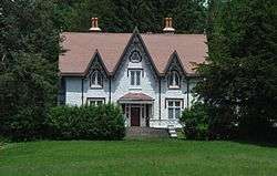
The Tempe Wick Road–Washington Corners Historic District in Harding and Mendham Township, New Jersey comprising Tempe Wick Road from US Route 202 to Cold Hill Road, and short segments of Corey Lane, Cemetery Road, Kenneday Road, Leddell Road, and Jockey Hollow Road.[3] The road is named for Temperance Wick.
See also
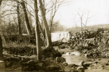
Ledell's Dam
References
- ↑ National Park Service (2009-03-13). "National Register Information System". National Register of Historic Places. National Park Service.
- ↑ "New Jersey and National Registers of Historic Places — Morris County" (PDF). New Jersey Department of Environmental Protection — Historic Preservation Office. 2016. Archived from the original (PDF) on 2012-10-24.
- ↑ https://npgallery.nps.gov/nrhp/GetAsset?assetID=9d33f915-822b-4893-89a0-272bfd562f41
This article is issued from
Wikipedia.
The text is licensed under Creative Commons - Attribution - Sharealike.
Additional terms may apply for the media files.