Tatebayashi, Gunma
| Tatebayashi 館林市 | |||
|---|---|---|---|
| City | |||
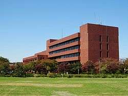 Tatebayashi city hall | |||
| |||
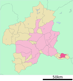 Location of Tatebayashi in Gunma Prefecture | |||
 Tatebayashi | |||
| Coordinates: 36°14′41.4″N 139°32′31.6″E / 36.244833°N 139.542111°ECoordinates: 36°14′41.4″N 139°32′31.6″E / 36.244833°N 139.542111°E | |||
| Country | Japan | ||
| Region | Kantō | ||
| Prefecture | Gunma Prefecture | ||
| Government | |||
| • Mayor | Kazuo Yasuraoka (since April 2007) | ||
| Area | |||
| • Total | 60.97 km2 (23.54 sq mi) | ||
| Population (February 2015) | |||
| • Total | 76,560 | ||
| • Density | 1,260/km2 (3,300/sq mi) | ||
| Time zone | UTC+9 (Japan Standard Time) | ||
| - Tree | Pinus thunbergii | ||
| - Flower | Rhododendron obtusum | ||
| - Bird | Anas poecilorhyncha | ||
| Phone number | 0276-72-4111 | ||
| Address | 1-1 Shiromachi, Tatebayashi-shi, Gunma-ken 374-8501 | ||
| Website | http://www.city.tatebayashi.gunma.jp/ | ||

Tatebayashi (館林市 Tatebayashi-shi) is a city located in Gunma Prefecture, Japan. As of February 2015, the city had an estimated population of 75,560, and a population density of 1260 persons per km². Its total area is 60.97 km². Tatebayashi is famous for Azalea Hill Park and Bunbuku Chagama of Morinji Temple.
Geography
Tatebayashi is located in the extreme southeastern portion of Gunma Prefecture in the Kantō Plains, bordered by Tochigi Prefecture to the north. The Tone River and Watarase Rivers pass through the city.
Surrounding municipalities
History
During the Edo period, the area of present-day Tatebayashi was a castle town and administrative center of Tatebayashi Domain, a feudal domain under the Tokugawa shogunate in Kōzuke Province.
Tatebayashi Town was created within Ōra District, Gunma Prefecture on April 1, 1889 with the creation of the municipalities system after the Meiji Restoration. On April 1, 1954 the town of Tatebayashi and the villages of Satoya, Ōshima, Akabane, Rokugō, Minoya, Tatara, and Watarase merged to form the city Tatebayashi.
There is a small community of around 200 Rohingya from Myanmar living in Tatebayashi.[1][2]
Economy
Tatebayashi is a regional commercial center and transportation hub. Food processing dominates the manufacturing sector of the local economy.
Education
There are two public and one private high school, five public middle schools and 11 public elementary schools in Tatebayashi
University
Transportation
Railway
Highway
- Tōhoku Expressway – Tatebayashi IC
- Japan National Route 122
- Japan National Route 354
Local attractions
- Site of Tatebayashi Castle
- Gunma Museum of Art, Tatebayashi
- Gunma Prefectural Tsutsujigaoka Park
- Jō-numa marsh
- Tatara-numa marsh
- Morinji Temple
Sister-city relations


Notable people
- Katai Tayama, novelist
- Kenjiro Shoda, mathematician
- Chiaki Mukai, astronaut and doctor [5]
References
- ↑ Shintomi, Tetsuo Student films documentary about Rohingya in Gunma Prefecture February 2, 2016 Japan Times Retrieved June 23, 2016
- ↑ Bleak prospects for Rohingya refugee in Japan September 3, 2013 Yomiuri Shimbun Retrieved June 23, 2016
- ↑ "Sister Cities and International Partnerships". http://business.sunshinecoast.qld.gov.au. Sunshine Coast Regional Council. May 6, 2015. External link in
|website=(help) - ↑ "Kunshan China". The People's Government of Kunshan. Archived from the original on April 29, 2015. Retrieved May 7, 2015.
- ↑ "Biographical Data: CHIAKI MUKAI (M.D., PH.D.) JAXA ASTRONAUT (PAYLOAD SPECIALIST)". http://www.jsc.nasa.gov. National Aeronautics and Space Administration. October 2013. External link in
|website=(help)
External links
![]()
- Official Website (in Japanese)

| Core cities | ||
|---|---|---|
| Special cities | ||
| Cities | ||
| Districts | ||
| Authority control |
|---|