Tarryall, Colorado
| Tarryall, Colorado | |
|---|---|
| Town | |
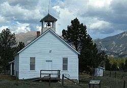 Tarryall School is listed on the National Register of Historic Places | |
| Coordinates: 39°07′19″N 105°28′32″W / 39.12194°N 105.47556°WCoordinates: 39°07′19″N 105°28′32″W / 39.12194°N 105.47556°W | |
| Country |
|
| State |
|
| Counties | Park[1] |
| Founded | 1896 |
| Elevation[1] | 8,714 ft (2,656 m) |
| Time zone | UTC-7 (MST) |
| • Summer (DST) | UTC-6 (MDT) |
| ZIP code[2] | 80827 (Lake George) |
Tarryall is an unincorporated town of cabins and old buildings in eastern Park County, Colorado, United States. The town is located on Tarryall Creek in the eastern edge of the South Park, between Lake George and Jefferson.
History
The town was founded in 1896 as Puma City, in response to mineral discoveries in the area. Within its first year, it reach a peak population of about a thousand residents. The Tarryall Post Office soon opened to serve the town. The population dwindled as the mineral discoveries proved to be much smaller than first thought. In the 1900s, the town took the name of its post office, Tarryall.[3] Only a handful of residents remain.
References
- 1 2 "US Board on Geographic Names". United States Geological Survey. 2007-10-25. Retrieved 2008-01-31.
- ↑ "ZIP Code Lookup" (JavaScript/HTML). United States Postal Service. Retrieved September 13, 2007.
- ↑ Robert L. Brown, 2003, Ghost towns of the Colorado Rockies, Caxton Press, ISBN 0-87004-342-0, p.286-290
External links
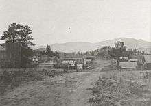
Puma City, 1898
Municipalities and communities of Park County, Colorado, United States | ||
|---|---|---|
| Towns | 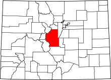 | |
| CDP | ||
| Unincorporated communities | ||
| Ghost towns | ||
This article is issued from
Wikipedia.
The text is licensed under Creative Commons - Attribution - Sharealike.
Additional terms may apply for the media files.