Tarneit, Victoria
| Tarneit Melbourne, Victoria | |||||||||||||||
|---|---|---|---|---|---|---|---|---|---|---|---|---|---|---|---|
 Tarneit | |||||||||||||||
| Coordinates | 37°49′59″S 144°40′19″E / 37.833°S 144.672°ECoordinates: 37°49′59″S 144°40′19″E / 37.833°S 144.672°E | ||||||||||||||
| Population | 34,562 (2016)[1] | ||||||||||||||
| • Density | 905.48/km2 (2,345.2/sq mi) | ||||||||||||||
| Postcode(s) | 3029 | ||||||||||||||
| Area | 38.17 km2 (14.7 sq mi) | ||||||||||||||
| Location | |||||||||||||||
| LGA(s) | City of Wyndham | ||||||||||||||
| State electorate(s) | Tarneit | ||||||||||||||
| Federal Division(s) | Lalor | ||||||||||||||
| |||||||||||||||
Tarneit (![]()
According to forecast.id Tarneit's population is estimated to increase to 63,512 in 2031.[2]
It is an emerging suburb in the City of Wyndham and neighbours another emerging suburb, Truganina.
History
Settlement of the area dates to the 1830s when Tarneit was used as agricultural grazing land. Tarneit was named when it was surveyed in 1839 - 1840 and comes from the Wathaurong word for the colour white. The road network was largely planned in a square mile grid pattern and still forms the basis of the arterial road network today. Large scale residential subdivision did not begin until the 1990s.
Land use
Tarneit is mostly used as agricultural grazing land. However this landscape has rapidly been changing due to the urban sprawl mainly coming from the community of nearby suburbs, such as Hoppers Crossing and Werribee, mostly happening in the southern part of Tarneit.
Tarneit has a number of schools established within its boundaries, including Thomas Carr College, Baden Powell Prep - Year 9 College and Tarneit Central College. The Islamic College of Melbourne (ICOM), located at Wootten Road, classes from Grade 1 to Grade 10 in 2016.
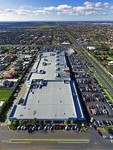
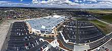
There has been much residential growth occur in the Thomas Carr District, with other schools and shopping centres planned for construction. Construction of stage one of Tarneit Central Shopping Centre, on the south east corner of Derrimut and Leakes Roads, begun construction in mid 2016, and was opened in October 2017. It includes a Coles and Aldi supermarket, Kmart, Harris Scarfe, and the Reject Shop.
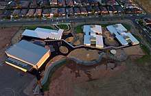
Wyndham Village Shopping Centre, in the suburb's south, was completed in 2005 to serve the exploding population in the immediate area, especially in the residential developments of Tarneit Gardens, The Rise that sits on the highest point of the surrounding plains, Rose Grange and Seasons.
Tarneit Town Centre, to be developed over the next 10 years, is expected to be located in the area loosely bounded by Derrimut Road to the west, Leakes Road to the south, Skeleton Creek to the east and Dry Creek to the north.[3]
Tarneit and other neighbouring suburbs such as Truganina are expected to grow rapidly as more established City of Wyndham suburbs are exhausted for land space.
Housing estates
The Tarneit area is now the site of several new housing estates, including Newgate, Habitat on Davis Creek Estate, Seasons Estate, The Heartlands, The Reflections Estate, Moorookyle, Tarneit Gardens, Ecoville, The Rise, Manhattan Place, Claremont Park, The Reserve, Rothwell Villages, Westbrook, Haven, NewHaven and Rose Grange. Mooted estates include Evadene, located within the Claremont Park estate.
Transport
Leakes Road has recently undergone redevelopment and is now sealed from Fitzgerald Road to Tarneit Road and provides a link from the industrial areas of Altona North and Laverton North to Tarneit and Hoppers Crossing. It is planned to ease traffic congestion on Sayers Road, which services Hoppers Crossing commuters travelling to and from the city. During peak hour the road is often a traffic nightmare for locals.[4]
In 2010, the Wyndham Bus Network was extensively upgraded and now caters for commuters from Tarneit.[5]
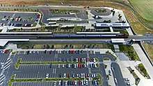
A new railway line opened in 2015, the Regional Rail Link, travels from West Werribee through Tarneit to Deer Park and includes a new railway station at Tarneit. The new station, built near the north east corner of Derrimut and Leakes Roads, provides a much faster service than the current Werribee railway line, which must pass through Altona and Footscray. It has car parking with 1,000 spaces, ensuring Tarneit becomes a prime regional area for those who commute to the city on a regular basis. Regional Rail Link also connects the Melton and Werribee railway lines and re-direct Geelong V/Line trains from the Werribee Line. Regional Rail Link opened on 21 June 2015, with Tarneit railway station coming under metropolitan zone 2.
See also
References
- ↑ Australian Bureau of Statistics (27 June 2017). "Tarneit (State Suburb)". 2016 Census QuickStats. Retrieved 21 July 2017.

- ↑ Archived 3 April 2011 at the Wayback Machine., Forecast.id. Retrieved 15 September 2010
- ↑ http://webadmin.gaa.vic.gov.au/Assets/Files/GCP%20-%20Chapter%204%20West%20Corridor%20Plan.pdf%5Bpermanent+dead+link%5D
- ↑ https://vpa.vic.gov.au/wp-content/uploads/2013/07/Leakes-Pty-Ltd-96A-southern-Cardno-Traffic-Report.pdf
- ↑ , New bus routes for Wyndham . Retrieved 15 September 2010