Tapajós
| Tapajós River | |
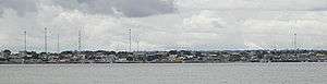 The city of Itaituba on the banks of the Tapajós River | |
| Country | Brazil |
|---|---|
| Tributaries | |
| - left | Juruena River, Arapiuns River |
| - right | Teles Pires, Cururu River, Das Tropas River, Crepori River, Jamanxim River |
| Source | |
| - location | Juruena–Teles Pires junction, Brazil |
| - coordinates | 7°20′15″S 58°8′35″W / 7.33750°S 58.14306°W |
| Mouth | Amazon River |
| - location | Santarém, Pará State, Brazil |
| - coordinates | 2°24′30″S 54°44′12″W / 2.40833°S 54.73667°WCoordinates: 2°24′30″S 54°44′12″W / 2.40833°S 54.73667°W |
| Length | 1,930 km (1,199 mi) [1] |
| Discharge | |
| - average | 13,540 m3/s (478,161 cu ft/s) |
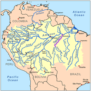 Map of the Amazon Basin with the Tapajós River highlighted | |
The Tapajós (Portuguese: Rio Tapajós [ˈʁi.u tɐpɐˈʒɔs]) is a river in Brazil. It runs through the Amazon Rainforest and is a major tributary of the Amazon River. When combined with the Juruena River, the Tapajós is approximately 1,200 mi (1,900 km) long.[1] It is one of the largest clearwater rivers,[2] accounting for about 6% of the water in the Amazon basin.[3]
Course
For most of its length the Tapajós runs through Pará State, but the upper (southern) part forms the border between Pará and Amazonas State. The source is at the Juruena–Teles Pires river junction.[1] The Tapajós River basin accounts for 6% of the water in the Amazon Basin, making it the fifth largest in the system.[4]
From the lower Arinos River (a tributary of Juruena) to the Maranhão Grande falls are a more or less continuous series of formidable cataracts and rapids; but from the Maranhão Grande to the mouth of Tapajós, about 188 mi (303 km), the river can be navigated by large vessels.
For its last 100 mi (160 km) it is between 4 and 9 mi (6.4 and 14.5 km) wide and much of it very deep. The valley of the Tapajós is bordered on both sides by bluffs. They are from 300 to 400 ft (91 to 122 m) high along the lower river; but a few miles above Santarém, they retire from the eastern side and do not approach the Amazon floodplain until some miles below Santarém.
Geography
The eastern border of Amazônia National Park is formed by the Tapajós River. From Itaituba and southwest a part of the Trans-Amazonian Highway (BR-230) follows the river, while a part of BR-163 runs parallel to the river from Santarém and south.
The South American pole of inaccessibility is located close to the sources of Tapajós's tributaries, near town Utiariti
The Tapajós is named after the Tapajós people, an extinct group of indigenous people from Santarém.
Ecology

The Tapajós is one of three major clearwater rivers in the Amazon Basin (the others are Xingu and Tocantins; the latter arguably outside the Amazon).[2][6] Clearwater rivers share the low conductivity and relatively low levels of dissolved solids with blackwater rivers, but differ from these in having water that at most only is somewhat acidic (typical pH ~6.5)[2] and very clear with a greenish colour.[6] About 325 fish species are known from the Tapajós River basin, including 65 endemics.[7] Many of these have only been discovered within the last decade, and a conservative estimate suggests more than 500 fish species eventually will be recognized in the river basin.[7]
Proposed dams
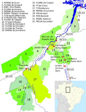
The fish, along with many other endemic species of flora and fauna are threatened by the Tapajós hydroelectric complex dams that are planned on the river.[7] The largest of those projects is the São Luiz do Tapajós Dam, whose environmental licensing process has been suspended - not yet cancelled - by IBAMA due to its expected impacts on indigenous and river communities.[8] It would flood a part of the area of the Sawré Muybu Indigenous Territory. Another is the planned 2,338 MW Jatobá Hydroelectric Power Plant.[9] A third dam, the controversial Chacorão Dam, would flood a large area of the Munduruku Indigenous Territory.[10]
The dams are part of a plan to convert the Tapajos into a waterway for barges to take soybeans from Mato Grosso to the Amazon River ports. A continuous chain of dams, with locks, would eliminate today's rapids and waterfalls.[10] The Washington Post has referred to this issue as the next battle over saving the Amazon as a result of its controversy involving Indigenous communities, the Brazilian government, large multinationals and international environmental organizations.[11]
In popular culture
The river is the sixth title of the album Aguas da Amazonia.
References
- 1 2 3 Ziesler, R.; Ardizzone, G.D. (1979). "Amazon River System". The Inland waters of Latin America. Food and Agriculture Organization of the United Nations. ISBN 92-5-000780-9. Archived from the original on 8 November 2014.
- 1 2 3 Duncan, W.P.; and Fernandes, M.N. (2010). Physicochemical characterization of the white, black, and clearwater rivers of the Amazon Basin and its implications on the distribution of freshwater stingrays (Chondrichthyes, Potamotrygonidae). PanamJAS 5(3): 454-464.
- ↑ "Waters". Amazon Waters. Retrieved 10 October 2017.
- ↑ Hales, J., and P. Petry (2013). Tapajos - Juruena. Freshwater Ecoregions of the World. Retrieved 16 February 2013.
- ↑ "Geophagus sp. 'orange head'". SeriouslyFish. Retrieved 22 October 2017.
- 1 2 Giovanetti, T.A.; and Vriends, M.M. (1991). Discus Fish, p. 15. Barron's Educational Serie. ISBN 0-8120-4669-2
- 1 2 3 The Great Rivers Partnership: Tapajós River Basin. Retrieved 16 February 2013.
- ↑ "Amazon mega-dam suspended, providing hope for indigenous people and biodiversity". Conservation news. Retrieved 2016-04-22.
- ↑ "Brazil sets concession auction for 8,040-MW Sao Luiz do Tapajos hydro project", Hydro World, Brasilia: PennWell Corporation, 17 September 2014, retrieved 2017-02-13
- 1 2 Fearnside, Philip M. (2015), "Amazon dams and waterways: Brazil's Tapajo´s Basin plans" (PDF), AMBIO, 44: 426, doi:10.1007/s13280-015-0642-z, PMC 4510327, PMID 25794814, retrieved 2017-02-13
- ↑ "This will be the next battle over saving the Amazon". Washington Post. Retrieved 2016-04-22.
| Wikimedia Commons has media related to Tapajós. |
Further reading
- Heinsdijk, Dammis, and Ricardo Lemos Fróes. Description of Forest-Types on "Terra Firme" between the Rio Tapajós and the Rio Xingú in the Amazon Valley. 1956.