Tannbach (Saale)
| Tannbach | |
|---|---|
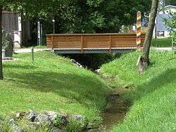 The Tannbach in Mödlareuth | |
| Country | Germany |
| States | Bavaria and Thuringia |
| Physical characteristics | |
| Main source |
east of Gefell-Gebertsreuth 620 m (2,030 ft) NN 50°26′11.44″N 11°54′12.54″E / 50.4365111°N 11.9034833°E |
| River mouth |
Saale (between Joditz and Hirschberg ) 445 m (1,460 ft) NN 50°23′38″N 11°50′06″E / 50.3939°N 11.8349°ECoordinates: 50°23′38″N 11°50′06″E / 50.3939°N 11.8349°E |
| Length | 8.7 km (5.4 mi) [1] |
| Basin features | |
| Progression | Saale→ Elbe→ North Sea |
| Tributaries |
|
Tannbach is a brook that is around nine kilometers long in north-east Bavaria and southern Thuringia, Germany.
The source is located east of Gefell in the Saale-Orla-Kreis district, in Thuringia, Germany. Initially it flows south through Gebersreuth before reaching Mödlareuth. During the Cold War the little brook marked the border between West- and East Germany and divided the little village into two parts. After Mödlareuth it flows in south-westerly direction before it joins the Saale as right tributary.
See also
References
- ↑ Complete table of the Bavarian Waterbody Register by the Bavarian State Office for the Environment (xls, 10.3 MB)
This article is issued from
Wikipedia.
The text is licensed under Creative Commons - Attribution - Sharealike.
Additional terms may apply for the media files.