Takeo, Saga
| Takeo 武雄市 | |||
|---|---|---|---|
| City | |||
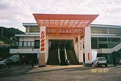 Takeo keirinjou entrance | |||
| |||
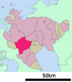 Location of Takeo in Saga Prefecture | |||
 Takeo Location in Japan | |||
| Coordinates: 33°12′N 130°1′E / 33.200°N 130.017°ECoordinates: 33°12′N 130°1′E / 33.200°N 130.017°E | |||
| Country | Japan | ||
| Region | Kyushu | ||
| Prefecture | Saga Prefecture | ||
| Government | |||
| • Mayor | Tadashi Komatu | ||
| Area | |||
| • Total | 195.44 km2 (75.46 sq mi) | ||
| Population (October 1, 2016) | |||
| • Total | 48,845 | ||
| • Density | 250/km2 (650/sq mi) | ||
| Symbols | |||
| • Tree | Cinnamomum camphora | ||
| • Flower | Rhododendron | ||
| Time zone | UTC+9 (JST) | ||
| City hall address |
1-1 Ōaza Shōwa, Takeo-chō, Takeo-shi, Saga-ken 843-8639 | ||
| Website | Takeo City on Facebook | ||


Takeo (武雄市 Takeo-shi) is a city located in Saga Prefecture on the island of Kyushu, Japan. In 2011, the city government was the first in Japan to switch to using Facebook for its website.[1]
As of October 1, 2016, the city has an estimated population of 48,845 and a population density of 257 persons per km². The total area is 195.44 km².
On March 1, 2006, the towns of Kitagata and Yamauchi (both from Kishima District) were merged into Takeo.
Geography
Takeo is located in the western part of Saga Prefecture. It is approximately 28 kilometers (17 mi) west of Saga City and approximately 30 kilometers (19 mi) east of Sasebo. Takeo has a complex topography including mountains, mountain basins and riverside plains.
- Mountains: Mt. Mifune (210 m), Mt. Hachiman (764 m), Mt. Bi (518 m), Mt. Jinroku (447 m)
- Rivers: Rokkaku River, Shiomi River, Yamanaka River
Adjoining municipalities
History
- 1889-04-01 - The modern municipal system was established. The current city region is occupied by 1 town (Takeo) and 11 villages (Asahi, Hashishita, Higashikawanobori, Kitagata, Kitsu, Nakato, Nishikawanobori, Sumiyoshi, Takeo, Takeuchi and Wakaki).
- 1900-06-07 - Takeo Village was incorporated into Takeo Town.
- 1944-04-29 - Kitamura Village became Kitamura Town.
- 1954-04-01 - Takeo Town absorbed the villages of Asahi, Hashishita, Higashikawanobori, Nishikawanobori, Takeuchi and Wakagi to create Takeo City. The villages of Sumiyoshi and Nakato were merged to create Yamauchi Village.
- 1956-04-01 - Hashishita Village was split and was incorporated into Kitagata and Shiroishi (respectively).
- 1960-09-01 - Yamauchi Village became Yamauchi Town.
- 2006-03-01 - The towns of Kitagata and Yamauchi were incorporated into Takeo City.
Education
High schools
- Saga Prefectural Takeo High School
Junior high schools
- Takeo Junior High School
- Takeo Kita Junior High School
- Kawanobori Junior High School
- Kitagata Junior High School
- Yamauchi Junior High School
- Seiryo Junior High School
Elementary schools
- Takeo Elementary School
- Mifunegaoka Elementary School
- Asahi Elementary School
- Tachibana Elementary School
- Wakaki Elementary School
- Takeuchi Elementary School
- Higashikawanobori Elementary School
- Nishikawanobori Elementary School
- Kitagata Elementary School
- Yamauchi Higashi Elementary School
- Yamauchi Nishi Elementary School
Transportation
Air
The nearest airports are Saga Airport followed by Nagasaki Airport.
Rail
The main station is Takeo-Onsen.
Road
- Expressways:
- Nagasaki Expressway
- Takeo-Kitagata Interchange - Kawanobori Service Area - Takeo Junction
- Nishi-Kyūshū Expressway
- Takeo Junction - Takeo Minami Interchange
- Nagasaki Expressway
- National highways:
- Main prefectural roads:
Notable places and festivals
- Takeo Onsen
- Takeo Jinja
- Takeo Keirin Track
- Saga Prefectural Space and Science Museum
- Mifunegaoka Plum Grove
- Kitagata Shiki no Oka Park
- Daishō-ji
- Chūō Park
- Mt. Kurokami, Fūfu Rock
- Kurokami no Roman festival
Sister cities
References
- ↑ Rick Martin Japanese City Website Gets a Facelift, Shifts to Facebook August 4, 2011
External links
| Wikimedia Commons has media related to Takeo, Saga. |
| Wikivoyage has a travel guide for Takeo. |
| Special city | ||
|---|---|---|
| Cities | ||
| Districts | ||