Taher
| Taher الطاهير Tahir | |
|---|---|
| City and Common | |
.JPG) Taher | |
| Motto(s): "From the people, for the people" | |
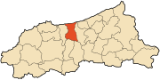 Location of Taher in the Jijel Province | |
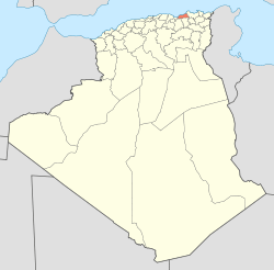
 Taher Location of Taher in the Algeria | |
| Coordinates: 36°46′19″N 5°53′54″E / 36.77194°N 5.89833°ECoordinates: 36°46′19″N 5°53′54″E / 36.77194°N 5.89833°E | |
| Country |
|
| Province | Jijel Province |
| District | Taher District |
| APC | 2012-2017 |
| Government | |
| • Type | Municipality |
| • Mayor | Hafid Boumahrouk[1] (RND) |
| Area | |
| • Total | 2,504 sq mi (64,86 km2) |
| Population (2008) | |
| • Total | 78,500 [2] |
| • Density | 31,350/sq mi (1,210,3/km2) |
| Time zone | UTC+1 (CET) |
| Postal code |
18200 18002 |
| ISO 3166 code | CP |
Taher (Arabic: الطاهير, Al-Tahir; Algerian Arabic: أطًهير), is Algerian city, the industrial center of Jijel Province, with its industrial area of Ouled Salah, the airport of Achouat-Ferhat Abbas and the port of Djen Djen.
Situation
The municipality of Taher is located in the north of Jijel Province.
Localities of the town
Taher is composed of several locations:
|
|
History
The present city is located on the site of an ancient city - dating back to Ottoman period - it was built on aboriginal lands hunted in the nearby mountains, after the revolt of 1871 (see Mokrani Revolt) time of occupation of Algeria by France, whose population was expropriated, including: the plain of Oued Djen-djen, Telata, the Ouled Bel Afou, Wadi Nile Beni Afar, Beni Siar, Beni khatab, and the immediate vicinity of the current city
Personalities
- Ferhat Abbas, first president of the Provisional Government of the Algerian Republic.
- Dekhli Mokhtar, one fighter of the FLN in Taher and the Algerian east.
 Sidi Yahia Mosque in downtown of Taher.
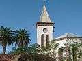 The church Taher.
.jpg) Sidi Yahia Mosque in downtown of Taher.
Sidi Yahia Mosque in downtown of Taher..jpg) The church Taher (Downtown).
The church Taher (Downtown).
References
- ↑ Jijel Info Archived 2013-01-05 at the Wayback Machine.
- ↑ ONS Statistic (Jijel province)
External links
| Wikimedia Commons has media related to Taher. |
- (in French) Jijel news