Tab District
| Tab District Tabi járás | ||
|---|---|---|
| Districts of Hungary | ||
| ||
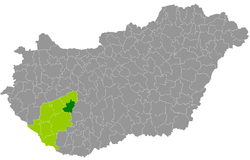 Tab District within Hungary and Somogy County. | ||
| Country |
| |
| Region | Southern Transdanubia | |
| County | Somogy | |
| District seat | Tab | |
| Area | ||
| • Total | 427.24 km2 (164.96 sq mi) | |
| Area rank | 8th in Somogy | |
| Population (2011 census) | ||
| • Total | 12,797 | |
| • Rank | 8th in Somogy | |
| • Density | 30/km2 (80/sq mi) | |

Tab (Hungarian: Tabi járás) is a district in north-eastern part of Somogy County. Tab is also the name of the town where the district seat is found. The district is located in the Southern Transdanubia Statistical Region.
Geography
Tab District borders with Siófok District to the north, Tamási District (Tolna County) to the east, Dombóvár District (Tolna County) and Kaposvár District to the south, Fonyód District to the west. The number of the inhabited places in Tab District is 24.
Municipalities
The district has 1 town and 23 villages. (ordered by population, as of 1 January 2013)[1]
- Andocs (1,110)
- Bábonymegyer (816)
- Bedegkér (430)
- Bonnya (251)
- Fiad (138)
- Kapoly (670)
- Kánya (422)
- Kára (47)
- Kisbárapáti (418)
- Lulla (175)
- Miklósi (220)
- Nágocs (656)
- Sérsekszőlős (154)
- Somogyacsa (174)
- Somogydöröcske (132)
- Somogyegres (214)
- Somogymeggyes (497)
- Szorosad (106)
- Tab (4,430) – district seat
- Tengőd (447)
- Torvaj (245)
- Törökkoppány (428)
- Zala (245)
- Zics (361)
The bolded municipality is city.
See also
References
- ↑ "A KSH 2013. évi helységnévkönyve". ksh.hu. Retrieved 2017-12-26.
External links
| Town (1) |
| |
|---|---|---|
| Villages (23) | ||
This article is issued from
Wikipedia.
The text is licensed under Creative Commons - Attribution - Sharealike.
Additional terms may apply for the media files.