Tönisvorst
| Tönisvorst | ||
|---|---|---|
 Castle | ||
| ||
 Tönisvorst Location of Tönisvorst within Viersen district 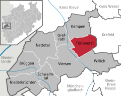  | ||
| Coordinates: 51°19′15″N 6°29′35″E / 51.32083°N 6.49306°ECoordinates: 51°19′15″N 6°29′35″E / 51.32083°N 6.49306°E | ||
| Country | Germany | |
| State | North Rhine-Westphalia | |
| Admin. region | Düsseldorf | |
| District | Viersen | |
| Government | ||
| • Mayor | Thomas Goßen (CDU) | |
| Area | ||
| • Total | 44.33 km2 (17.12 sq mi) | |
| Elevation | 36 m (118 ft) | |
| Population (2016-12-31)[1] | ||
| • Total | 29,235 | |
| • Density | 660/km2 (1,700/sq mi) | |
| Time zone | CET/CEST (UTC+1/+2) | |
| Postal codes | 47918 | |
| Dialling codes |
0 21 51 (St. Tönis) 0 21 56 (Vorst) | |
| Vehicle registration | VIE | |
| Website | www.toenisvorst.de | |

Tönisvorst is a town in the district of Viersen, in North Rhine-Westphalia, Germany. It is situated approximately 5 km west of Krefeld.
Historical monuments
- Das alte Rathaus, St. Tönis
- Der Mertenshof, St. Tönis
- Schluff (steam locomotive), St. Tönis
- Haus Raedt, Vorst
- Haus Brempt, Vorst
- Haus Neersdonk, Vorst
- Haus Donk, Vorst
- Der Gelleshof
Towns and municipalities in Viersen (district) | ||
|---|---|---|
References
- ↑ "Amtliche Bevölkerungszahlen" (in German). Landesbetrieb Information und Technik NRW. Retrieved 2018-02-24.
| Authority control |
|---|
This article is issued from
Wikipedia.
The text is licensed under Creative Commons - Attribution - Sharealike.
Additional terms may apply for the media files.