Szydłów, Lubusz Voivodeship
| Szydłów | |
|---|---|
| Village | |
 Szydłów | |
| Coordinates: 52°04′25″N 14°45′45″E / 52.07361°N 14.76250°ECoordinates: 52°04′25″N 14°45′45″E / 52.07361°N 14.76250°E | |
| Country |
|
| Voivodeship | Lubusz |
| County | Słubice |
| Gmina | Cybinka |
| Population | 0 |
Szydłów [ˈʂɨdwuf] (German: Schiedlo) is an abandoned village in the administrative district of Gmina Cybinka, within Słubice County, Lubusz Voivodeship, in western Poland, close to the German border.[1]
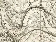
The settlement arose from a castle near the confluence of the Oder and Neisse rivers. In 1249 the Silesian Duke Bolesław II the Bald of Legnica granted it to the Lusatian margrave Henry III the Illustrious from the House of Wettin, in turn for his mediation in the inheritance conflict with his brother Duke Henry III the White of Wrocław. Schiedlo remained a village at the northeastern edge of Lower Lusatia, the only one east of the Oder River. From 1319 on it was a possession of Neuzelle Abbey.
With Lower Lusatia, it fell to Saxony by the 1635 Peace of Prague and to Prussia according to the Final Act of the 1815 Vienna Congress. Incorporated into the Province of Brandenburg, the area fell to the Republic of Poland with the 1945 implementation of the Oder–Neisse line (see Territorial changes of Poland after World War II). However, the village had already been abandoned in the early 20th century due to repeated floodings.
References
| Town and seat |  | |
|---|---|---|
| Villages | ||