Syltefjorden (Finnmark)
| Syltefjorden | |
|---|---|
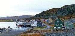 View of the abandoned fishing village of Nordfjord, located on the shore of the Syltefjorden | |
 Syltefjorden Location of the fjord  Syltefjorden Syltefjorden (Norway) | |
| Location | Finnmark county, Norway |
| Coordinates | 70°32′48″N 30°13′19″E / 70.5467°N 30.2220°ECoordinates: 70°32′48″N 30°13′19″E / 70.5467°N 30.2220°E |
| Type | Fjord |
| Primary inflows | River Syltefjordelva |
| Primary outflows | Barents Sea |
| Basin countries | Norway |
| Max. length | 16 kilometres (9.9 mi) |
| Max. width | 5 kilometres (3.1 mi) |
Syltefjorden is a fjord in Båtsfjord Municipality in Finnmark county, Norway. The 16-kilometre (9.9 mi) long fjord flows from the river Syltefjordelva on the large Varanger Peninsula into the Barents Sea. The Varangerhalvøya National Park lies just south of the fjord.[1]
Historically, there were three fishing villages located around the fjord: Nordfjord, Hamna, and Ytre Syltefjord. All three villages were abandoned during the 20th century. Along the northern shore of the fjord lies the large Syltefjordstauran mountain. The mountain is home to a very large bird colony that is popular with tourists.[2]
References
- ↑ "Syltefjorden" (in Norwegian). yr.no. Retrieved 2013-02-26.
- ↑ Store norske leksikon. "Syltefjordstauran" (in Norwegian). Retrieved 2013-02-26.
External links
This article is issued from
Wikipedia.
The text is licensed under Creative Commons - Attribution - Sharealike.
Additional terms may apply for the media files.