Sylamore, Arkansas
| Sylamore, Arkansas | |
|---|---|
| Unincorporated community | |
 Sylamore  Sylamore | |
| Coordinates: 35°56′29″N 92°06′30″W / 35.94139°N 92.10833°WCoordinates: 35°56′29″N 92°06′30″W / 35.94139°N 92.10833°W | |
| Country | United States |
| State | Arkansas |
| County | Izard |
| Elevation | 338 ft (103 m) |
| Time zone | UTC-6 (Central (CST)) |
| • Summer (DST) | UTC-5 (CDT) |
| Area code(s) | 870 |
| GNIS feature ID | 73810[1] |
Sylamore is an unincorporated community in Izard County, Arkansas, United States. Sylamore is located on the White River and Arkansas Highway 9 in southern Izard County, 5.1 miles (8.2 km) north of Mountain View.[2]
References
- ↑ "Sylamore". Geographic Names Information System. United States Geological Survey.
- ↑ Izard County, Arkansas General Highway Map (PDF) (Map). Arkansas State Highway and Transportation Department. 2003. Retrieved February 15, 2013.
Municipalities and communities of Izard County, Arkansas, United States | ||
|---|---|---|
| Cities | 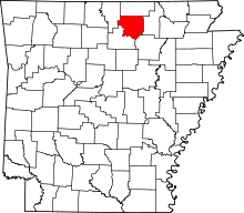 | |
| Towns | ||
| Unincorporated communities | ||
| Footnotes | ‡This populated place also has portions in an adjacent county or counties | |
This article is issued from
Wikipedia.
The text is licensed under Creative Commons - Attribution - Sharealike.
Additional terms may apply for the media files.