Sydney Harbour Bridge cycleway
| Sydney Harbour Bridge cycleway | |
|---|---|
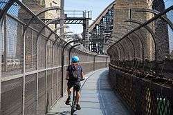 A cyclist riding north to south along the cycleway, pictured in 2015. | |
| Length | 2 kilometres (1.2 mi)[1] |
| Location | Sydney, New South Wales, Australia |
| Trailheads |
|
| Use | Cycling only |
| Elevation | |
| Highest point | 51 metres (167 ft) AHD |
| Lowest point | 14 metres (46 ft) AHD |
| Cycling details | |
| Trail difficulty | Easy |
| Season | All seasons |
The Sydney Harbour Bridge cycleway is a 2-kilometre-long (1.2 mi)[1] conjoined cycleway from the north and south that crosses the Sydney Harbour Bridge on its western side, linking the Sydney central business district with North Sydney, Sydney's Northern Suburbs and the North Shore, in Sydney, New South Wales, Australia.[2]
Route
The southern terminus of the cycleway is at Millers Point with access to Argyle Street and Upper Fort Street in The Rocks. At its southern terminus near the Sydney Observatory, the cycleway is located adjacent to the Western Distributor and connects with the Kent Street cycleway. The northern terminus of the cycleway is at Burton Street, Milsons Point, just below Milsons Point railway station. From this location riders ascend 55 stairs in order to access the path that is located on the roadway level, some 51 metres (167 ft) above the water level.[3] A campaign to eliminate the steps on this popular cycling route to the CBD has been running since at least 2008.[4][5]
The absence of an efficient or safe cycleway or cycle paths to access the Bridge has resulted in the HarbourLink proposal[6] to give better access to the Sydney Harbour Bridge's northern approach. The NSW Bike Plan 2010[7] identified Naremburn to the Harbour Bridge as one of 13 "major missing links" and a "priority metropolitan link". On 7 December 2016 the NSW Roads Minister Duncan Gay confirmed that the northern stairway would be replaced with a A$20 million ramp alleviating the needs for cyclists to dismount. At the same time the NSW Government announced plans to upgrade the southern ramp at a projected cost of A$15 million. Both projects are expected to completed by late 2020.[8][9][10]
At the northern terminus there is a long-term plan to link the Sydney Harbour Bridge cycleway with the Gore Hill and Epping Road cycleways, to the northwest.[11]
Cycleway use
In the 12 months to February 2014 between 2,000 and 3,000 cyclists used the Sydney Harbour Bridge cycleway on an average weekday.[12]
The NSW Roads Regulations states that a person must not ride a bicycle on any part of the Sydney Harbour Bridge other than a cycleway.[13]
See also
References
- 1 2 32 Burton Street, Kirribilli NSW 2061 to Western Distributor & Kent Street & Bradfield Highway & Sydney Harbour Bridge, Millers Point NSW 2000 (Map). Google Maps. 2016. Retrieved 5 December 2016.
- ↑ "Cycleway Finder". Roads & Maritime Services (Version 3 ed.). Government of New South Wales. 2016. Retrieved 4 December 2016.
- ↑ "Sydney Harbour Bridge". harbourbrindge.com.au. Nutting Industries Pty. Ltd. Retrieved 7 December 2016.
- ↑ "HarbourLink". Sydneyharbourlink.com. Archived from the original on 26 January 2014. Retrieved 9 June 2014.
- ↑ HarbourLink – North Sydney Council Archived 22 October 2012 at the Wayback Machine.
- ↑ "Sydney Harbour Link". Archived from the original on 28 May 2010.
- ↑ "NSW Bikeplan 2010" (PDF). Archived from the original (PDF) on 19 May 2012.
- ↑ McNally, Lucy (7 December 2016). "Sydney Harbour Bridge cyclists can expect $35 million bike ramp and upgrade by 2020". ABC News. Australia. Retrieved 7 December 2016.
- ↑ Stempien, Filip (7 December 2016). "New ramps and cycleways for Sydney Harbour Bridge". The Sydney Morning Herald. Retrieved 7 December 2016.
- ↑ McNab, Heathery (8 August 2016). "Plan in the works to ramp up access to Sydney Harbour Bridge". Daily Telegraph. Australia. Retrieved 7 December 2016.
- ↑ Saulwick, Jacob (19 December 2013). "'Sydney's Cycling Future': North shore and inner west cyclists face further delays for paths under state government plan". The Sydney Morning Herald. Retrieved 10 December 2016.
- ↑ "Cycling statistics". Roads and Maritime Services. Government of New South Wales. March 2016.
- ↑ Roads (General) Regulation, 2000 (NSW)
External links
- Bicycle NSW website
- City of Sydney - Cycling
- "NSW Bike Plan". Bicycle Information for New South Wales. Archived from the original on 21 November 2013.