Swift Current Airport
| Swift Current Airport | |||||||||||||||
|---|---|---|---|---|---|---|---|---|---|---|---|---|---|---|---|
|
| |||||||||||||||
 | |||||||||||||||
| Summary | |||||||||||||||
| Airport type | Public | ||||||||||||||
| Operator | City of Swift Current | ||||||||||||||
| Location | Swift Current No. 137, near Swift Current, Saskatchewan | ||||||||||||||
| Time zone | CST (UTC−06:00) | ||||||||||||||
| Elevation AMSL | 2,681 ft / 817 m | ||||||||||||||
| Coordinates | 50°17′33″N 107°41′27″W / 50.29250°N 107.69083°WCoordinates: 50°17′33″N 107°41′27″W / 50.29250°N 107.69083°W | ||||||||||||||
| Website | Swift Current Airport Webpage | ||||||||||||||
| Map | |||||||||||||||
 CYYN Location in Saskatchewan  CYYN CYYN (Canada) | |||||||||||||||
| Runways | |||||||||||||||
| |||||||||||||||
| Statistics (2006) | |||||||||||||||
| |||||||||||||||
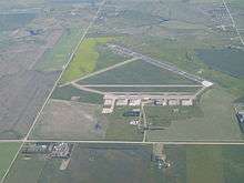
Swift Current Airport (IATA: YYN, ICAO: CYYN) is located 4 nautical miles (7.4 km; 4.6 mi) east of Swift Current, Saskatchewan, Canada.
History
1930-1939
Swift Current Airport began as a crude aerodrome in the 1930s, part of Canada’s national “100-mile interval” aerodrome system.
1939-1945 World War II
Shortly after the outbreak of WWII, a British Commonwealth Air Training Plan (BCATP) base was established to train Royal Air Force (RAF) pilots on intermediate aircraft. The base was named “#39 Service Flying Training School” and operated until late 1944. The base was 1 of more than 100 similar facilities constructed across Canada during WWII, a major infrastructure project (even by today’s standards) that provided jobs for communities still reeling from the Great Depression.
Some of the infrastructure from the WWII training base remains today. The airfield layout, that is the runways and taxiways, retains virtually the same configuration as it did originally. One of the seven original WWII hangar remains today. The building is structurally sound and has been granted a “municipal heritage site” designation. The owner is completing some restorative work to the exterior. Another notable object from WWII is the large concrete structure at the east end of the apron - it was referred to as “25-yard firing range”. A few other original buildings remain, such as the water pump house, workshop, storage buildings. Some buildings have been re-purposed within the City.
Aerodrome
In approximately 1942 the aerodrome was listed as "RCAF & D of T Aerodrome Swift Current" at 50°17′N 107°43′W / 50.283°N 107.717°W with a Var. 19 degrees E and elevation of 2,670 feet (814 m). The field was listed as "Hard surfaced" and had Six runways listed as follows:[4]
| Runway Name | Length | Width | Surface |
|---|---|---|---|
| 7/25 | 3,500 feet (1,067 m) | 100 feet (30 m) | Hard Surfaced |
| 7/25 | 3,600 feet (1,097 m) | 100 feet (30 m) | Hard Surfaced |
| 3/21 | 2,830 feet (863 m) | 100 feet (30 m) | Hard Surfaced |
| 3/21 | 2,830 feet (863 m) | 100 feet (30 m) | Hard Surfaced |
| 11/29 | 2,850 feet (869 m) | 100 feet (30 m) | Hard Surfaced |
| 11/29 | 2,850 feet (869 m) | 100 feet (30 m) | Hard Surfaced |
Relief landing field – St. Aldwyn
The primary relief landing field(R1) for RCAF Station Swift Current was located north of the city of Swift Current, Saskatchewan. In approximately 1942 the aerodrome was listed at 50°23′N 107°46′W / 50.383°N 107.767°W with a Var. 20 degrees E and an elevation of 2,633 feet (803 m). The Relief field was laid out in a triangle with three runways, detailed in the following table:[5]
| Runway Name | Length | Width | Surface |
|---|---|---|---|
| 7/25 | 2,900 feet (884 m) | 100 feet (30 m) | Hard Surface |
| 1/19 | 2,900 feet (884 m) | 100 feet (30 m) | Hard Surface |
| 13/31 | 2,900 feet (884 m) | 100 feet (30 m) | Hard Surface |
Relief landing field – Wymark
The secondary relief landing field(R2) for RCAF Station Swift Current was located northeast of the community of Wymark, Saskatchewan. In approximately 1942 the aerodrome was listed at 50°10′N 107°43′W / 50.167°N 107.717°W with a Var. 19.5 degrees E and an elevation of 2,902 feet (885 m). The Relief field was laid out in a triangle with three runways and was listed as a "Turf All way field", the runways were listed as follows:[6]
| Runway Name | Length | Width | Surface |
|---|---|---|---|
| 13/31 | 3,800 feet (1,158 m) | 500 feet (152 m) | Turf |
| 7/25 | 3,800 feet (1,158 m) | 500 feet (152 m) | Turf |
| 1/19 | 3,800 feet (1,158 m) | 500 feet (152 m) | turf |
1945-Present
Following the end of WWII, the airport was operated by the Department of Transport (now Transport Canada) until the late 1990s. At that time, the federal government implemented the National Airports Policy which transitioned ownership of medium-sized airports to local municipalities. The airport had scheduled passenger services in the 1950s and 60s provided by Trans-Canada Airways (now Air Canada). Over the years, the airport has served as a base for corporate aircraft, government aircraft, military aircraft, agricultural aircraft, private aircraft, flight training, aircraft maintenance and refueling.
Services
Swift Current Airport has the following services: cardlock fuel pumps (accepting VISA, American Express and MasterCard) dispensing 100LL gasoline and Jet A-1 turbine fuel, 24-hour pilot's lounge with WiFi and washrooms, aircraft maintenance company (Craft Aviation), parking and tie-downs.
References
- ↑ Canada Flight Supplement. Effective 0901Z 19 July 2018 to 0901Z 13 September 2018.
- ↑ Synoptic/Metstat Station Information
- ↑ Total aircraft movements by class of operation
- ↑ Staff Writer c.1942, p. 66
- ↑ Staff Writer c.1942, p. 65
- ↑ Staff Writer c.1942, p. 69
- Staff writer (c. 1942). Pilots Handbook of Aerodromes and Seaplane Bases Vol. 2. Royal Canadian Air Force.
External links
- Swift Current Airport
- Page about this airport on COPA's Places to Fly airport directory
- South West Flying Club - COPA Flight 107
- Past three hours METARs, SPECI and current TAFs for Swift Current Airport from Nav Canada as available.
| By name | |
|---|---|
| By location indicator | |
| By province/territory | |
| By area | |
| National Airports System | |
| Related | |
| |