Svarstad
| Svarstad | |
|---|---|
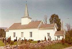 Svarstad Church | |
| Coordinates: 59°24′N 9°58′E / 59.400°N 9.967°ECoordinates: 59°24′N 9°58′E / 59.400°N 9.967°E | |
| Country | Norway |
| County | Vestfold |
| Municipality | Larvik |
| Area | |
| • Total | 0.71 km2 (0.27 sq mi) |
| Population (2011) | |
| • Total | 566 |
| • Density | 800/km2 (2,100/sq mi) |
| Time zone | UTC+1 (CET) |
| • Summer (DST) | UTC+2 (CEST) |
| Postal code | 3275 |
Svarstad is a village in Larvik, Norway. Its population (2011) is 566,[1] and it is situated on the Numedalslågen river, approximately 46 kilometres (29 mi) north of urban Larvik and 11 kilometres (6.8 mi) south of Hvittingfoss in Kongsberg municipality. Svarstad Church was built in 1657 and is located here.
Svarstad ski center ran 8 ski slopes for both children and adults until the start of winter 2015, when it closed due to bankruptcy. Holemyra is a fairly sizable forested area located in the midst of Svarstad, and this is also a popular picnic and hiking area with residents.
References
- ↑ "Tabell 1 Tettsteder. Folkemengde og areal, etter kommune. 1.januar 2011". Statistics Norway. Archived from the original on June 30, 2012. Retrieved June 30, 2012.
This article is issued from
Wikipedia.
The text is licensed under Creative Commons - Attribution - Sharealike.
Additional terms may apply for the media files.