Surmo
| Surmo سرمو | |
|---|---|
| Village | |
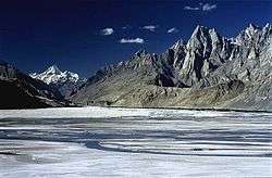 The 7,821 m (25,659 ft) tall Masherbrum as viewed from Surmo | |
 Surmo سرمو Location in Pakistan | |
| Coordinates: 35°9′6.5181″N 76°26′43.6057″E / 35.151810583°N 76.445446028°ECoordinates: 35°9′6.5181″N 76°26′43.6057″E / 35.151810583°N 76.445446028°E | |
| Country | Pakistan |
| Province | Gilgit Baltistan |
| District | Ghangche |
| Elevation | 8,532.504 ft (2,600.707, m) |
| Population | |
| • Total | 10,000 |
| Time zone | UTC+5 (PST) |
| • Summer (DST) | UTC+6 (GMT+6) |
Surmo Valley (Urduوادی سرمو) is a valley in Ghangche District, in Gilgit–Baltistan, Pakistan. Etymologically, the name is derived from sermo : ser meaning gold and mo is a suffix used to feminise the word.
Location
Surmo is located approximately 12 kilometres (7.5 mi) from the district administrative capital of Khaplu. Its neighborhoods are Choghogrong, Tarkari, Khar, Gond, Langkhung, Tishari and Ghazi-Thang, containing 800 houses and approximately 10,000 people. Cultural symbols include Rgyalmo Khar, Shagharun khar and Minduq Sar (flower garden).
History
Surmo is one of the oldest valleys of Baltistan. It contains 150-year-old walnut trees. In 1996, stupas were found here. Local people called this place Rgyalmo Khar (a queen's palace).[1]
Geography
Surmo is important with respect to military and transportation networks in the mountainous region. Its biggest bridge, Surmo Bridge, links Siachen region with the district capital of Khaplu, as well as Chorbat Valley, making this valley strategically important.
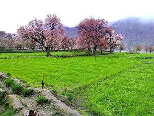
Surmo was formerly a fertile and prosperous area. A well-known local expression was Surmo ma drang na gar ma drang ("if your stomach is not full or stuffed in Surmo, there is no other place it would be"). The shifts in flow of the glacier-sourced Shyok river (literally the river of death) have caused considerable damage, the slow and steady kind of devastation that resulted in landslides. Many fields were lost in this way over the past century, leaving only 20% of the fields on the riverside which are not cut-off due to flooding.
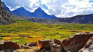
Surmo Broq, a site of terraced fields hundreds of feet above the valley, is one of the beautiful Broqs in Baltistan. Dakholi Lake is located there at a distance of few meters above the broq. Ringbothang, a newly cultivated land near the bridge, is another source of earning and farming. Another enormous uncultivated land of Surmo is called Tunga.
Surmo has several beautiful meadows and lakes where local people take their livestock during the summer season, they spend the whole season there till winter, two famous meadows are Zingkhashing and Surat.
Welfare Organizations
The people of Surmo are considered as one of the well-organized and educated people in Baltistan. Aga Khan Development Network and Anjumane Falah o Behbood Surmo are among the oldest welfare organizations of Baltistan working in the region for the welfare and development of the locals for many decades.
The young generation of Surmo is struggling in education, and dreams of Surmo as a well-developed village in future. Youth organization "Skarchan" is playing vital role in various fields of life like health care and education as well as for better environment of the area.