Surisan
| Surisan | |
|---|---|
 | |
| Highest point | |
| Elevation | 469[1] m (1,539 ft) |
| Coordinates | 37°22′N 126°52′E / 37.367°N 126.867°ECoordinates: 37°22′N 126°52′E / 37.367°N 126.867°E |
| Geography | |
 Surisan | |
| Climbing | |
| Easiest route | Hike, scramble |
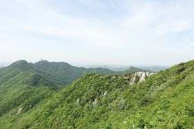
Surisan(수리산) is a mountain that forms a boundary between Anyang and Gunpo in Gyeonggi-do, Korea.[2] The height of Surisan is 488m, and another name of Surisan is 'Gyeonbulsan'. There are some temples such as sangyeonsa, yongjinsa,and surisa located on the mountain and surrounding area. In the spring, Azaleas were in full bloom all over the mountain. Kyeong-gi do designated Surisan as Park of Gyeong-gi in 2009.
Geography
SuriSan is a mountain on the border of Anyang City and Gunpo City, Gyeonggi-Province, and has a lot of azalea in the spring. There are many rocks on the way to the mountains, and in the spring, azaleas are reddish. So many climbers gather. There are many mineral springs where clear water springs out in Suri-san. In addition, there are temples such as Sang-Yeon Temple, Yong-Jin Temple, Suri Temple. It is also called GyeonBulSan. In the "Ansan City" item in "Sejong Sillok Jiriji", "this mountain is called 'Chi San'". In "SinJung DongGukYeoJiSeongRam", "Ansan" item says "There is 'Surisan', which is also called GyunBulSan." In the same book 'GwaCheon City', Surisan is said to be located in the southern part of GwaCheon. In the Ansan City section of "DaeDdongJiJi" compiled by 'KimJungHo', Surisan was mentioned, and it is said to be "in the east 5th, also called TaeEulSan and GyunBulSan, this mountain is quite tough and high." It was a famous mountain from the Joseon Dynasty. The mountain's peaks were very prominent and the mountain's valleys were deep. The peaks and cliffs are generally quartz. The valleys are rich in weathered biotite, horny gneiss and gneissic gneisses, and partly biotite schist. Gwan-Mo, Seul-Gi, and Suam, Tae-Eul are peaks of this mountain. Among these peaks, Tae-Eul peak is the highest peak. The height of Tae-Eul peak is 489.2m above sea level. According to Feng Shui theory, the appearance of a large eagle with two wings is considered a very rare phenomenon. This shape is called 'Tae-eul'. When you go up to Tae-eul Peak at sunrise and look down at the shadow, you can see a big 'Tae-eul' shape.[3]
Origin name
1. The remarkable peaks of Suri are like eagles[4]
2. The temple, which was built during the Jin-hung King of Silla , was called the Suri Temple because it was a holy place to practice body and mind. Since then, the mountain name was called "SuriSan".
3. During the Joseon Dynasty, the son of the Joseon's king, whose first name was Lee, trained in this mountain. So, 'Su' which means 'training' and 'Lee' were combined and called SuriSan.
Area
SuriSan is located at 126 ° 50 "to 126 ° 55" east longitude and 37 ° 20 "to 37 ° 24" north latitude. The height of this mountain is 469m. The total area is 36.155㎢. Among them, Anyang city occupies 19.5㎢, Gunpo city occupies 10.475㎢, and Ansan city occupies 6.18㎢.[5]
Course
Surisan is also loved by mountain bike riders. SuriSan is easy to access near Line 4 train. SuriSan's typical climbing course passes by 'Gunpo Central Library' and goes uphill for about 200 meters up to the entrance of the temple. This course is about 11km, which can be turned around in about two hours. It is one of the easiest courses in the metropolitan area, including slope, area, view, and floor condition. There is also a single course, such as a ridge single course that runs from the five-way Intersection to the southeast, and a road that goes right down the stairs from the five-way Intersection paddle. However, because of the narrow roads, the riders do not go well except for a few places due to the entry-exit.[6]
The course that goes up through the 'bottleneck' from Anyang side is difficult because the slope is fast and the floor is not good. It's a very difficult extreme single course that can not be climbed by regular XC bikes. There is only a climber because it is difficult to ride a bicycle to a course that leads to Sukbong-Jangmobong.[6]
Most mountain climbing courses overlap with mountain bike riders' courses, and beginner hikers and local residents often use the course. There are several benches in the course and you can relax. However, there is no water in Surisan except for water from the front of the repair shop. However, the quantity is small except for the summer season. There is no stall in the mountain, so you have to prepare water. There is a water spring at the entrance to the library at the bottom of SuriSan, and there is a Banwol lake at the southwest.[6]
Natural Environment
SuriSan is one of the mountainous regions that make up the Gwang-ju Mountain Range and is located northwest of the Gunpo City. There are Seul-Gi peak (451.5m) in the southwest, Gwan-Mo peak (426m) in the northwest, and Su-Am peak (395m) in the southwest, centered on Tae-Eul peak (489m).[4]
The upper part of the forest is deciduous broad - leaved trees, with oak and Mongolian mulberry predominating. Overall, mammals appear to be relatively rare in species and populations. SuriSan has a mole, rabbits, boot, dog, raccoons, and weasels.[4]
Tale
Yellow Rock Tale
Yellow rock is a rock in the middle of 'Gwan-Mo Peak' which is the upper part of 'SanSinJe Temple'. Once upon a time, a king was worried that there was no prince to win the throne for over 40 years. They prayed with diligence. A grand prince was born who was inspired by God. A war broke out in the year when the prince was three years old. The prince leaves the palace and flew to GangHwaDo to escape, but he meets a storm. When the boat is wrecked, a turtle appears and takes the prince to the land. The turtle arrives at the edge of GwanMo Peak while looking for shelter. The appearance of the prince starving at the turtle's back and starving for days seemed pitiful. The turtle went down to the village to find the food for the prince, but the prince, unaware of the thought of the turtle, misunderstands that the turtle has abandoned himself. So the prince hit rock with his fist as hard as he could. At the moment, the rock fell and the prince struck with a great sound that shook the heavens and the earth. And the prince dies with yellow blood. Also, the turtle was hit by a pouring rock like hail. Thereafter, there is a story that the stone of the prince's blood is called 'yellow rock' and the rock with the monument is called 'turtle rock' in a village of Anyang City.[7]
History
SuriSan Battle
The Surinan battle was a battle that took place in Surisan, northwestern Suwon, from February 1 to February 2, 1951, during the Korean War. The US 1st Corps was attempting to advance into the south of the Han River by launching a counterattack operation on January 25, 1951. At this time, the 35th regiment of the 25th division of the United States and the Turkish Brigade made a major contribution to repulse and northward attack by attacking the 149th Division of the 50th Division of the CCP, which was defending occupation of SuriSan in the northwestern part of Suwon. In this battle, the 35th Regiment and the Turkish Brigade received the support of the US 999 artillery army and the US 89th tank battalion, surrounded the Surat Mountains on both sides and attacked the base of the 149th Division of the Civilization, They defeated the enemy and seized the goal. It also effectively defeated the counter-attack of the Chinese Army, which was launched immediately after the target's takeover, and kept its position. As a result of this battle, the Chinese army withdrew from the Suwon area and retreated to the Anyang area in the north, and the UN forces were able to continue northward to secure the Han River line.[8]
Recent
1. Selection of course in SuriSan forest
Anyang City selected Surisan Forest Exploratory Class as a specialization subject and is used as a best practice for the urban renewal New Deal project. SuriSan Forest Exploratory Class is a representative village community activation program of Anyang city started last year. For this class, Anyang City invites a specialist forest explorer to explore the mangrove forests and listen detailed explanations of the specialist forest commentator about the natural vegetation inhabited there. In this class, activities that utilize natural vegetation are conducted.[9]
2. Opening a forest experience for the treatment of atopy in SuriSan
Atomic Forest Experiential Class was held in the SuriSan Forest Park with 50 children and parents participating. This experiential classroom was set up after citizens first took the theoretical education on understanding and management of atopic dermatitis and allergic rhinitis twice. Participants interacted with nature in the forests of SuriSan Forest and conducted forest experience in accordance with the guidance of the forest explorer. They also boosted their immunity through phytoncide compounds in forests with excellent antimicrobial activity. In this regard, the Sanbon Health Center, including SuriSan, operates 43 inpatient and asthma relief facilities in the region and conducts preventive management education and health care throughout the year to create an environment where children can learn healthily.[10]
References
- ↑ "수리산" (in Korean). Retrieved 2018-05-10.
- ↑ "수리산도립공원" [Information of Surisan]. korean.visitkorea.or.kr (in Korean). Retrieved 2018-06-02.
- ↑ "수리산" (in Korean). Retrieved 2018-06-24.
- 1 2 3 "수리산(修理山) - 한국민족문화대백과사전". Encyclopedia of Korean Culture (in Korean). Retrieved 2018-05-24.
- ↑ "수리산" (in Korean). Retrieved 2018-05-07.
- 1 2 3 "[이두영의 가볼만한 산] 안산 수리산 수암봉- 부드러운 산길에 진달래꽃 철쭉꽃이 함께하는 수도권 주말나들이 명소 - 스포츠Q(큐)" (in Korean). 2017-03-06. Retrieved 2018-06-18.
- ↑ "수리산 전설". https://terms.naver.com/entry.nhn?docId=2646619&cid=51896&categoryId=54005. External link in
|website=(help) - ↑ "수리봉전투" (in Korean). Retrieved 2018-06-13.
- ↑ 강, 근주 (2018-05-19). "안양시 '수리산 숲 탐방' 특성화 교과목 선정" [Selected as a specialization course for 'Surin Mountain Forest' in Anyang City]. The financial news. Retrieved 2018-05-24.
- ↑ "산본보건지소 `수리산 아토피 숲` 체험". 경인일보 (in Korean). Retrieved 2018-06-13.