Superior Township, Williams County, Ohio
| Superior Township, Williams County, Ohio | |
|---|---|
| Township | |
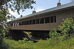 St. Joseph River covered bridge, shared with Montpelier | |
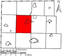 Location of Superior Township in Williams County | |
| Coordinates: 41°34′40″N 84°37′12″W / 41.57778°N 84.62000°WCoordinates: 41°34′40″N 84°37′12″W / 41.57778°N 84.62000°W | |
| Country | United States |
| State | Ohio |
| County | Williams |
| Area | |
| • Total | 43.8 sq mi (113.4 km2) |
| • Land | 43.6 sq mi (112.8 km2) |
| • Water | 0.2 sq mi (0.6 km2) |
| Elevation[1] | 863 ft (263 m) |
| Population (2000) | |
| • Total | 5,769 |
| • Density | 132.5/sq mi (51.1/km2) |
| Time zone | UTC-5 (Eastern (EST)) |
| • Summer (DST) | UTC-4 (EDT) |
| FIPS code | 39-75819[2] |
| GNIS feature ID | 1087177[1] |
Superior Township is one of the twelve townships of Williams County, Ohio, United States. The 2000 census found 5,769 people in the township, 1,452 of whom lived in the unincorporated portions of the township.[3]
Geography
Located in the central part of the county, it borders the following townships:
- Bridgewater Township - north
- Madison Township - northeast
- Jefferson Township - east
- Pulaski Township - southeast corner
- Center Township - south
- St. Joseph Township - southwest corner
- Florence Township - west
- Northwest Township - northwest corner
It is one of only two county townships (the other being Jefferson Township) without a border on another county.
Most of the village of Montpelier is located in northeastern Superior Township.
Name and history
Superior Township was organized in 1839.[4] It is the only Superior Township statewide.[5]
Government
The township is governed by a three-member board of trustees, who are elected in November of odd-numbered years to a four-year term beginning on the following January 1. Two are elected in the year after the presidential election and one is elected in the year before it. There is also an elected township fiscal officer,[6] who serves a four-year term beginning on April 1 of the year after the election, which is held in November of the year before the presidential election. Vacancies in the fiscal officership or on the board of trustees are filled by the remaining trustees.
References
- 1 2 "US Board on Geographic Names". United States Geological Survey. 2007-10-25. Retrieved 2008-01-31.
- ↑ "American FactFinder". United States Census Bureau. Retrieved 2008-01-31.
- ↑ Williams County, Ohio — Population by Places Estimates Ohio State University, 2007. Accessed 15 May 2007.
- ↑ Bowersox, Charles A. (1920). A Standard History of Williams County, Ohio: An Authentic Narrative of the Past, with Particular Attention to the Modern Era in the Commercial, Industrial, Educational, Civic and Social Development. Lewis Publishing Company. p. 394.
- ↑ "Detailed map of Ohio" (PDF). United States Census Bureau. 2000. Retrieved 2007-02-16.
- ↑ §503.24, §505.01, and §507.01 of the Ohio Revised Code. Accessed 4/30/2009.
External links
Municipalities and communities of Williams County, Ohio, United States | ||
|---|---|---|
| City | 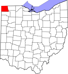 | |
| Villages | ||
| Townships | ||
| CDPs | ||
| Unincorporated communities | ||
| Ghost town | ||