St. Joseph Township, Williams County, Ohio
| St. Joseph Township, Williams County, Ohio | |
|---|---|
| Township | |
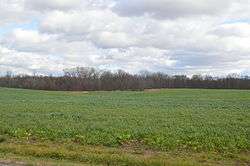 Countryside just north of Edgerton | |
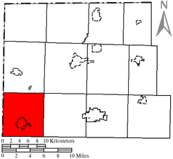 Location of St. Joseph Township in Williams County | |
| Coordinates: 41°27′35″N 84°44′48″W / 41.45972°N 84.74667°WCoordinates: 41°27′35″N 84°44′48″W / 41.45972°N 84.74667°W | |
| Country | United States |
| State | Ohio |
| County | Williams |
| Area | |
| • Total | 35.1 sq mi (91.0 km2) |
| • Land | 35.1 sq mi (90.8 km2) |
| • Water | 0.1 sq mi (0.2 km2) |
| Elevation[1] | 833 ft (254 m) |
| Population (2000) | |
| • Total | 2,958 |
| • Density | 84.4/sq mi (32.6/km2) |
| Time zone | UTC-5 (Eastern (EST)) |
| • Summer (DST) | UTC-4 (EDT) |
| FIPS code | 39-69638[2] |
| GNIS feature ID | 1087175[1] |
St. Joseph Township is one of the twelve townships of Williams County, Ohio, United States. The 2000 census found 3,227 people in the township, 1,821 of whom lived in the unincorporated portions of the township.[3]
Geography
Located in the southwestern corner of the county along the Indiana line, it borders the following townships:
- Florence Township - north
- Superior Township - northeast corner
- Center Township - east
- Farmer Township, Defiance County - southeast corner
- Milford Township, Defiance County - south
- Stafford Township, DeKalb County, Indiana - southwest
- Troy Township, DeKalb County, Indiana - west
The village of Edgerton is located in southern St. Joseph Township.
Name and history
It is the only St. Joseph Township statewide.[4]
Government
The township is governed by a three-member board of trustees, who are elected in November of odd-numbered years to a four-year term beginning on the following January 1. Two are elected in the year after the presidential election and one is elected in the year before it. There is also an elected township fiscal officer,[5] who serves a four-year term beginning on April 1 of the year after the election, which is held in November of the year before the presidential election. Vacancies in the fiscal officership or on the board of trustees are filled by the remaining trustees.
References
- 1 2 "US Board on Geographic Names". United States Geological Survey. 2007-10-25. Retrieved 2008-01-31.
- ↑ "American FactFinder". United States Census Bureau. Retrieved 2008-01-31.
- ↑ Williams County, Ohio — Population by Places Estimates Ohio State University, 2007. Accessed 15 May 2007.
- ↑ "Detailed map of Ohio" (PDF). United States Census Bureau. 2000. Retrieved 2007-02-16.
- ↑ §503.24, §505.01, and §507.01 of the Ohio Revised Code. Accessed 4/30/2009.
External links
Municipalities and communities of Williams County, Ohio, United States | ||
|---|---|---|
| City | 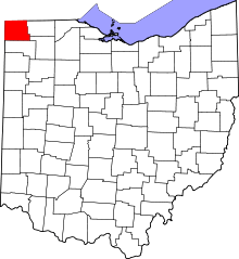 | |
| Villages | ||
| Townships | ||
| CDPs | ||
| Unincorporated communities | ||
| Ghost town | ||