Sumgal
Coordinates: 36°16′23″N 78°46′50″E / 36.27306°N 78.78056°E

NASA satellite image showing the towns of Sumgal in Ladakh and Pusa in southwestern Hotan, and the Hindu-tash Pass connecting them. The pass is marked in bright red.
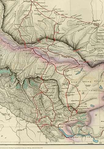
Details of a map of Kashmir (1878) showing the Hindutash Pass and Hotan as well as the northern border regions of the British Indian Empire (which included the Kashmir region).[1] The international border is shown in the two-toned purple and pink band. The mountain passes are shown in bright red. Warning the lat/long information is not everywhere correct.
Sumgal (literally, "three fords," in Uyghur language) is a historical ford and horse-changing station on the right bank of the Karakash River just before it enters the Aksai Chin plateau in the western Xinjiang Uyghur Autonomous Region (formerly, Chinese Turkestan) of the People's Republic of China. It is on the southwest side of the Kunlun Mountains and downstream from the now-deserted town of Kangxiwar, formerly Kengshewar, (36° 11' 58 N, 78° 46' 50 E) on the Karakash River[1]
See also
References
Notes
- 1 2 (Trotter 1878, p. U8)
General sources
- Johnson, W. H. (1867), "Report on His Journey to Ilchí, the Capital of Khotan, in Chinese Tartary", Journal of the Royal Geographical Society of London, 37 (1): 1–47, JSTOR 1798517 .
- Schlagintweit, Hermann; Schlagintweit, Adolphe; Schlagintweit, Robert (1861), Results of a Scientific Mission to India and High Asia: undertaken between the years MDCCCLIV and MDCCCLVIII, Leipzig/London: F. A. Brockhaus/Trubner and Co. .
- Stein, M. Aurel (1909), "Explorations in Central Asia, 1906-8", The Geographical Journal, 34 (1): 5–36, doi:10.2307/1777985, JSTOR 1777985 .
- Stein, M. Aurel (1911), "Note on Maps Illustrating Dr. Stein's Explorations in Chinese Turkestan and Kansu", The Geographical Journal, 37 (3): 275–280, doi:10.2307/1777400, JSTOR 1777400 .
- Trotter, H. (1878), "On the Geographical Results of the Mission to Kashghar, under Sir T. Douglas Forsyth in 1873-74", Journal of the Royal Geographical Society of London, 48 (2): 173–234, JSTOR 1798763 .
- Gazetteer of Kashmir and Ladak compiled under the direction of the Quarter Master | General in India in the Intelligence Branch. First Published in 1890 by the Superintendent of Government Printing, Calcutta. Compiled under the Direction of the Quartermaster -General in India in the Intelligence | Branch. 1890 Ed.
- Report of the Great Trigonometrical Survey of India, 1866, p. 6.
- Map referred to in Art.9 of the Simla Convention between Great Britain, China and Tibet, 1914 signed by the Chinese representative.
- Atlas of the northern frontiers of India . Pg.20
- Himalayan Frontiers by Dorothy Woodman. Pg.67-68
External links
This article is issued from
Wikipedia.
The text is licensed under Creative Commons - Attribution - Sharealike.
Additional terms may apply for the media files.