Upper Yafa
| State of Upper Yafa يافع العليا Yāfi‘ al-‘Ulyā | ||||||
| State of the Protectorate of South Arabia | ||||||
| ||||||
| ||||||
 | ||||||
| Capital | Mahjaba | |||||
| Government | Sultanate | |||||
| HRH Sultan | Muhammad ibn Salih ibn `Umar Al Harhara | |||||
| Historical era | 20th century | |||||
| • | Established | ca. 1800 | ||||
| • | Disestablished | 29 November 1967 | ||||
| Area | ||||||
| • | 1967 est. | 1,600 km2 (618 sq mi) | ||||
| Population | ||||||
| • | 1967 est. | 35,000 | ||||
| Density | 21.9 /km2 (56.7 /sq mi) | |||||


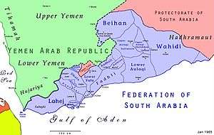
Upper Yafa or Upper Yafa'i (Arabic: يافع العليا Yāfi‘ al-‘Ulyā), officially State of Upper Yafa (Arabic: دولة يافع العليا Daulat Yāfiʿ al-ʿUlyā), was a state in the British Aden Protectorate and the Protectorate of South Arabia. It was ruled by the Harharah dynasty and its capital was Mahjaba, a small town on a hill located by road 621, about 50 km northeast of Habilayn.[1]
History
The Yafa'i tribe has traditionally inhabited the mountainous hinterland of the Aden area. In the 19th century it was formed by two sultanates, Lower and Upper Yafa. Upper Yafa included the five sheikhdoms of Al-Busi, Al-Dhubi, Al-Hadrami, Al-Muflihi, and Al-Mausata that were unified by the Harharah dynasty around 1800.[2] A treaty of Protection was signed between the British and the Sultan of Upper Yafa in 1903.[3]
The area of Upper Yafa had not been visited by Europeans before Colonel M.C. Lake of the British Indian Army explored it in order to gather intelligence and to find suitable sites for landing grounds. In 1925 Lake built a small army of tribal warriors that would be able to assist the British Aden Protectorate in eventual territorial scuffles with the Imam of Yemen.[4]
Between 1955 and 1957 there were uprisings against the British authorities in Upper Yafa that were successfully suppressed.[5] Unlike Lower Yafa, in the 1960s Upper Yafa did not join the British-sponsored Federation of South Arabia, forming an enclave that became a part of the Protectorate of South Arabia.
The Upper Yafa Sultanate was abolished in 1967 upon the founding of the People's Republic of South Yemen. South Yemen united with North Yemen in 1990 to form the Republic of Yemen.
Rulers
Sheikhs of Upper Yafa
c.1730 - 1735 `Ali ibn Ahmad ibn Harhara
c.1735 - 1750 Ahmad ibn `Ali Al Harhara
c.1750 - 1780 Salih ibn Ahmad Al Harhara
c.1780 - 1800 `Umar ibn Salih Al Harhara
Sultans of Upper Yafa
c.1800 - 1810 Qahtan ibn `Umar ibn Salih Al Harhara
c.1810 - 1815 `Umar ibn Qahtan ibn `Umar Al Harhara
c.1815 - 1840 Qahtan ibn `Umar ibn Qahtan Al Harhara
c.1840 - 1866 `Abd Allah ibn Nasir ibn Salih Al Harhara
1866 - 1875 al-Husayn ibn Abi Bakr ibn Qahtan Al Harhara
1875 - 28 Apr 1895 Muhammad ibn `Ali ibn Salih ibn Ahmad Al Harhara
1895 - 1903 Qahtan ibn `Umar ibn al-Husayn Al Harhara
4 Dec 1903 - 1913 Salih ibn `Umar ibn al-Husayn Al Harhara (1st time)
1913 - 1919 `Umar ibn Qahtan ibn `Umar Al Harhara
1919 - 1927 Salih ibn `Umar ibn al-Husayn Al Harhara (2nd time)
1927 - 1948 Umar ibn Salih ibn `Umar Al Harhara
1948 - 29 Nov 1967 Muhammad ibn Salih ibn `Umar Al Harhara
Postage stamps
The Sultanate of Upper Yafa issued stamps in September 1967 although Mahjaba did not have functioning postal services at that time.
Artistamp artist Bruce Grenville has created a set of stamps for the Sultanate of Upper Yafa.
Many further stamps were issued, not by the official authority, even after the dissolution of the Federation and the establishment of the Republic of South Yemen. These stamps can be found in the Phillips CD Catalogue of Oman State, Dhufar and South Arabia (Volume 15)
See also
References
- ↑ Picture of Mahjaba
- ↑ Treaties and Engagement relating to Aden and the South-Western Coast of Arabia Archived 2013-12-10 at the Wayback Machine. p. 18–20
- ↑ The British-Yemeni Society, Passage to Yafa’ (1891–1967) Archived 2013-07-21 at the Wayback Machine.
- ↑ Report by Lieut.-Colonel M C Lake on his visit to Upper and Lower Yafa., Middle East No. 8, The National Archives, Kew, 1926
- ↑ Waldemar Gruschke, Markenländer-Lexikon, vol. 3 N–Sh, 2006, p. 83, ISBN 3-8334-4936-5
External links
| Wikimedia Commons has media related to Sultanate of Upper Yafa. |
Coordinates: 13°49′51″N 45°15′20″E / 13.83083°N 45.25556°E