Sugar Loaf Island
 Sugar Loaf Island | |
 Sugar Loaf | |
| Geography | |
|---|---|
| Location | Greenland |
| Coordinates | 74°01′00″N 56°58′15″W / 74.01667°N 56.97083°WCoordinates: 74°01′00″N 56°58′15″W / 74.01667°N 56.97083°W |
| Archipelago | Upernavik Archipelago |
| Administration | |
|
Greenland | |
| Municipality | Qaasuitsup |
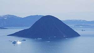
Sugar Loaf Island (Greenlandic: Uummannaq, old spelling: Ũmánaq) is a small, uninhabited island in the Qaasuitsup municipality in northwestern Greenland. The island is a single flooded mountain of 376 m (1,234 ft).[1] Its name means "heart-shaped" in the Greenlandic language. The island is an important landmark in the region often afflicted by fog, and is used for coastal boat navigation.
Geography
Sugar Loaf Island is located in the north-central part of Upernavik Archipelago, in the group between Kangerlussuaq Icefjord in the south, and Nuussuaq Peninsula in the north. The waters around the island are those of its namesake, the Sugar Loaf Bay, an indentiation of Baffin Bay.[1] The closest settlement is Nuussuaq, approximately 9.6 km (6.0 mi) to the north of the island.
References
| Wikimedia Commons has media related to Sugar Loaf Island. |