Ikermiut Island
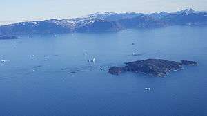 Aerial view of Ikermiut Island | |
 Ikermiut | |
| Geography | |
|---|---|
| Location | Greenland |
| Coordinates | 74°20′15″N 56°58′50″W / 74.33750°N 56.98056°WCoordinates: 74°20′15″N 56°58′50″W / 74.33750°N 56.98056°W |
| Archipelago | Upernavik Archipelago |
| Administration | |
|
Greenland | |
| Municipality | Qaasuitsup |
Ikermiut Island is a small, uninhabited island in the Qaasuitsup municipality in northwestern Greenland, located in the center of Inussulik Bay in the northern part of Upernavik Archipelago, approximately halfway between Kiatassuaq Island in the north and Nuussuaq Peninsula in the south.[1]
History
Ikermiut Island was permanently inhabited between 1916 and 1954, when a small settlement of the same name existed on the island. The settlement was abandoned in 1954, during the post-war consolidation phase in northwestern Greenland.[2]
References
This article is issued from
Wikipedia.
The text is licensed under Creative Commons - Attribution - Sharealike.
Additional terms may apply for the media files.