Suches, Georgia
| Suches, Georgia | |
|---|---|
| Unincorporated community | |
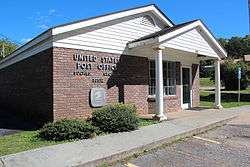 Post office in Suches | |
 Suches, Georgia Location within the state of Georgia  Suches, Georgia Suches, Georgia (the US) | |
| Coordinates: 34°41′20″N 84°01′20″W / 34.68889°N 84.02222°WCoordinates: 34°41′20″N 84°01′20″W / 34.68889°N 84.02222°W | |
| Country | United States |
| State | Georgia |
| County | Union |
| Elevation | 2,792 ft (851 m) |
| Time zone | UTC-5 (Eastern (EST)) |
| • Summer (DST) | UTC-4 (EDT) |
| Area code(s) | 706 & 762 |
| GNIS ID | 333148[1] |
Suches is an Unincorporated community in Union County, Georgia, United States.[1] With an elevation approaching 3,000 feet, Suches describes itself as "The Valley Above The Clouds"' and is one of the highest-elevation communities in the state. It is the birthplace of Arthur Woody, a forest ranger who was a key figure in the early history of Chattahoochee National Forest. Suches is approximately one mile from the Appalachian Trail (AT) as it passes through Woody Gap.
The local school is Woody Gap School, the smallest public school in the state of Georgia. The historical marker in front of the school lists it as the homestead of Joseph E. Brown, governor of Georgia during the Civil War. The current businesses in Suches include Two Wheels of Suches, High Valley Resort, Budget Propane, the general store, Mountain Property Limited (the local realtor), and the U.S. Post Office.
Until recently, the annual Tour de Georgia bicycle race has gone through Suches on its way to Dahlonega.
References
External links
Municipalities and communities of Union County, Georgia, United States | ||
|---|---|---|
| City | 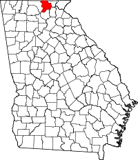 | |
| Unincorporated communities | ||