Substation Fire
| Substation Fire | |
|---|---|
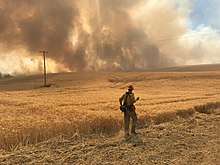 A firefighter assessing a fire line during the Substation Fire | |
| Location | Private land, The Dalles, Oregon, United States |
| Coordinates | 45°34′34″N 121°06′11″W / 45.576°N 121.103°WCoordinates: 45°34′34″N 121°06′11″W / 45.576°N 121.103°W |
| Statistics[1] | |
| Date(s) | July 22, 2018 – August 2, 2018 |
| Burned area | 78,425 acres (317 km2) |
| Cause | Unknown |
| Land use | Private |
| Map | |
 Location of fire in Oregon | |
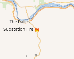 |
| Location of Substation Fire |
The Substation Fire was a wildfire in the U.S. state of Oregon near The Dalles. The fire was first reported on July 17, 2018, and had burned 78,425 acres (317 km2).[2]
Incidents
The Substation Fire was reported, burning on private land, in the late afternoon on July 17, 2018, five miles south of The Dalles, two miles west of Moro and near the border of Grass Valley. Strong winds caused the fire to grow rapidly, with the fire moving over 18 miles in days.[1] Agricultural and recreational areas suffered heavy damage and by July 18 Oregon Governor Kate Brown had declared a state of emergency, which included calling the Oregon National Guard to assist with fighting the fire and the communities of Moro, Grass Valley and Kent were evacuated.[2] The next day, evacuation orders were lifted, however a temporary flight restriction was put in place in the area.[3]
As of July 23, the fire had destroyed 78,425 acres (317 km2) and was 92 percent contained.[1]
References
- 1 2 3 "Substation Fire Incident Information". Cal Fire. State of California. Retrieved 23 July 2018.
- 1 2 "Substation Fire Now Number One Fire in the Nation; Additional Resources Add - InciWeb the Incident Information System". InciWeb. USDA Forest Service, Fire and Aviation Management. Retrieved 24 July 2018.
- ↑ "Reduced Evacuations, Some Containment Indicate Progress on Substation Fire - InciWeb the Incident Information System". InciWeb. USDA Forest Service, Fire and Aviation Management. Retrieved 24 July 2018.
External links
