Studenec (Semily District)
| Studenec | |||
|---|---|---|---|
| Municipality | |||
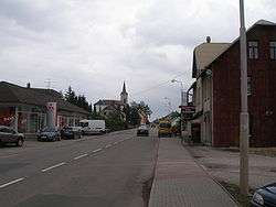 The main road and church of St. John the Baptist | |||
| |||
| Coordinates: 50°33′00″N 15°32′00″E / 50.55000°N 15.53333°ECoordinates: 50°33′00″N 15°32′00″E / 50.55000°N 15.53333°E | |||
| Country | Czech Republic | ||
| Region | Liberec | ||
| First documented | 14th century | ||
| Government | |||
| • mayor | Jiří Ulvr (2006) | ||
| Area | |||
| • Total | 17 km2 (7 sq mi) | ||
| Highest elevation | 630 m (2,070 ft) | ||
| Lowest elevation | 410 m (1,350 ft) | ||
| Population (2009) | |||
| • Total | 1,830 | ||
| Postal code | 512 33, 514 01 | ||
| Area code(s) | 481 | ||
| Website |
www | ||


Studenec is a municipality in Semily District in the Liberec Region of the Czech Republic. It consists of two villages, Studenec and Zálesní Lhota. Studenec entered[1] and won a medal in the Entente Florale in 2010
Famous people born in Zálesní Lhota
References
- ↑ "CZ_Studenec_pdf" (PDF). Retrieved 23 May 2012.
| Wikimedia Commons has media related to Studenec (Semily District). |
This article is issued from
Wikipedia.
The text is licensed under Creative Commons - Attribution - Sharealike.
Additional terms may apply for the media files.