Bělá (Semily District)
| Bělá | |||
|---|---|---|---|
| Municipality and village | |||
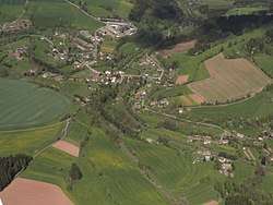 Aerial view | |||
| |||
 Bělá Location in the Czech Republic | |||
| Coordinates: 50°32′21″N 15°26′35″E / 50.53917°N 15.44306°ECoordinates: 50°32′21″N 15°26′35″E / 50.53917°N 15.44306°E | |||
| Country |
| ||
| Region | Liberec Region | ||
| District | Semily District | ||
| Elevation | 1,240 ft (378 m) | ||
| Population (2006) | |||
| • Total | 242 | ||
| Time zone | UTC+1 (CET) | ||
| • Summer (DST) | UTC+2 (CEST) | ||
Bělá is a village and municipality in Semily District in the Liberec Region of the Czech Republic.
External links

This article is issued from
Wikipedia.
The text is licensed under Creative Commons - Attribution - Sharealike.
Additional terms may apply for the media files.