Strydenburg
| Strydenburg | |
|---|---|
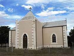 Reformed Church, Strydenburg | |
 Strydenburg  Strydenburg Strydenburg (South Africa)  Strydenburg Strydenburg (Africa) | |
| Coordinates: 29°56′S 23°40′E / 29.933°S 23.667°ECoordinates: 29°56′S 23°40′E / 29.933°S 23.667°E | |
| Country | South Africa |
| Province | Northern Cape |
| District | Pixley ka Seme |
| Municipality | Thembelihle |
| Established | 1892 |
| Area[1] | |
| • Total | 37.98 km2 (14.66 sq mi) |
| Population (2011)[1] | |
| • Total | 2,987 |
| • Density | 79/km2 (200/sq mi) |
| Racial makeup (2011)[1] | |
| • Black African | 10.2% |
| • Coloured | 83.9% |
| • Indian/Asian | 0.3% |
| • White | 5.2% |
| • Other | 0.4% |
| First languages (2011)[1] | |
| • Afrikaans | 93.5% |
| • Xhosa | 1.7% |
| • English | 1.6% |
| • Tswana | 1.2% |
| • Other | 2.0% |
| Time zone | UTC+2 (SAST) |
| Postal code (street) | 8765 |
| PO box | 8765 |
| Area code | 053 |
Strydenburg is a town in the east of the Northern Cape province in South Africa. Seventy-seven km north of Britstown, it was laid out by the Dutch Reformed Church on the farm Roodepan in 1892. It also lies on the N12, which separates the actual town from its township.
The town is 55km south-west of Hopetown and 75km north-north-west of Britstown. It was laid out in 1892 on the farm Roodepan and attained municipal status in 1914. The name is Dutch for ‘town of argument’. The name refers to disagreement as to on which farm it should be situated.[2]
References
- 1 2 3 4 "Main Place Strydenburg". Census 2011.
- ↑ "Dictionary of Southern African Place Names (Public Domain)". Human Science Research Council. p. 420.
External links
- Information about Strydenburg

Places adjacent to Strydenburg | |
|---|---|
Municipalities and communities of Pixley ka Seme District Municipality, Northern Cape | ||
|---|---|---|
District seat: De Aar | ||
| Emthanjeni | .svg.png) | |
| Kareeberg | ||
| Renosterberg | ||
| Siyancuma | ||
| Siyathemba | ||
| Thembelihle | ||
| Ubuntu | ||
| Umsobomvu | ||
This article is issued from
Wikipedia.
The text is licensed under Creative Commons - Attribution - Sharealike.
Additional terms may apply for the media files.