Strunjan
| Strunjan Strugnano | |
|---|---|
.jpg) Strunjan | |
 Strunjan Location in Slovenia | |
| Coordinates: 45°32′2.61″N 13°36′24.5″E / 45.5340583°N 13.606806°ECoordinates: 45°32′2.61″N 13°36′24.5″E / 45.5340583°N 13.606806°E | |
| Country |
|
| Region | Slovenian Littoral |
| Municipality | Piran |
| Area | |
| • Total | 3.51 km2 (1.36 sq mi) |
| Elevation | 37.7 m (123.7 ft) |
| Population (2002) | |
| • Total | 564 |
| [1] | |
Strunjan (pronounced [stɾuˈnjaːn] (![]()
Overview
The Strunjan Nature Reserve, located along a 4 km stretch of Adriatic coast to the north of the settlement, is the longest section of unspoilt coastline in the entire Gulf of Trieste.[3]
The parish church in the settlement is dedicated to the Virgin Mary.
Events
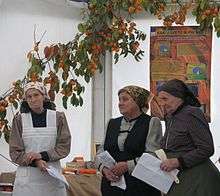
Persimmon Festival, 2005
Since 2001, Strunjan has held an annual persimmon festival (Slovene: Praznik kakijev) every November. Together with the Vipava Valley and the Gorizia Hills, Strunjan has a favorable microclimate for persimmon cultivation, producing 30% of Slovenia's annual persimmon crop on about 20 hectares.[4]
References
External links

- Strunjan on Geopedia
| Settlements |  | |
|---|---|---|
| Landmarks |
| |
| People |
| |
This article is issued from
Wikipedia.
The text is licensed under Creative Commons - Attribution - Sharealike.
Additional terms may apply for the media files.