Stroud, New South Wales
| Stroud New South Wales | |
|---|---|
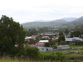 Stroud Town Centre | |
|
Stroud | |
| Coordinates | 32°24′0″S 151°58′0″E / 32.40000°S 151.96667°ECoordinates: 32°24′0″S 151°58′0″E / 32.40000°S 151.96667°E |
| Population | 938 (2016 census)[1] |
| Established | 1820s |
| Postcode(s) | 2425 |
| Location | |
| LGA(s) | Mid-Coast Council |
| State electorate(s) | Upper Hunter |
| Federal Division(s) | Lyne |
Stroud is a small country town one hour north of Newcastle, New South Wales, Australia. It is part of the Mid-Coast Council local government area. The major road through Stroud is the Bucketts Way. At the 2006 census, Stroud had a population of 669.[2]
The township of Stroud can trace its beginning back to the late 1820s when it became the headquarters for a public funded company known as the Australian Agricultural Company (A. A. Company). In 1824, this company received a grant of one million acres (4,000 km²) of land between Port Stephens and the Manning River. This land was to be used for agriculture.
Stroud was a self-contained village by 1832 and, as early as 1836, the Company's storehouses and much of the convict labour force were located there. By 1850, it had become the Company's headquarters. Land was subdivided for private settlement in 1849, with settlers arriving from England the following year to take up land grants there.
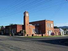
Many fine buildings were constructed at Stroud. Some of these are still in use today: Stroud House (1827–32); St John's Church (1833) and Quambi School House (late 1830s), and the underground grain silos, built by the A. A. Company for the storage of grain.
Sport
In 2007 the Stroud Raiders a men's football team reformed. With strong performances through the year the Raiders were the Minor and Major Premiers for 2007. There is also a women's football (soccer) team called the Supercats. Stroud also has a cricket team. These teams share the Stroud Showground. Stroud used to have four tennis courts which were home to the Stroud Tennis Club, and a twenty five metre pool which is usually open from October to April. Golf and bowls are played at the Stroud and District Country Club.[3]
Some of the sports facilities, along with houses, property and camping grounds, where severely damaged in April 2015 in a large storm that caused flash flooding.
Events
The Stroud Show is usually the first weekend after Easter.
The Stroud International Brick and Pin Throwing Contest is usually held on a Saturday in July . This coincides with the same event in three other Strouds: Oklahoma , Gloucestershire and Ontario.
The Stroud Rodeo is usually the third weekend in September.
Retreats and conferences are held at the Franciscan Monastery of the Blessed Virgin Mary.[4]
Education
Stroud has a primary school which was established in 1884.
Railways
It was not possible for the North Coast railway line to serve Stroud. A railway station was established at Stroud Road but this is now closed and the nearest station is at Dungog.
Heritage listings
Stroud has a number of heritage-listed sites, including:
- Cowper Street: St John the Evangelist Church[5]
- 42 Cowper Street: Stroud House[6]
Twin town
References
- ↑ Australian Bureau of Statistics (27 June 2017). "Stroud (State Suburb)". 2016 Census QuickStats. Retrieved 4 February 2018.

- ↑ Australian Bureau of Statistics (25 October 2007). "Stroud (L) (Urban Centre/Locality)". 2006 Census QuickStats. Retrieved 2009-09-17.
- ↑ http://www.stroudcountryclub.org.au/
- ↑ http://www.themonasterystroud.org.au/
- ↑ "St. John the Evangelist Anglican Church Group, New South Wales State Heritage Register (NSW SHR) Number H00330". New South Wales State Heritage Register. Office of Environment and Heritage. Retrieved 18 May 2018.
- ↑ "Stroud House, New South Wales State Heritage Register (NSW SHR) Number H01969". New South Wales State Heritage Register. Office of Environment and Heritage. Retrieved 18 May 2018.
External links
- "Karuah River and Great Lakes catchments" (map). Office of Environment and Heritage. Government of New South Wales.