Stratford City
| Stratford City | |
|---|---|
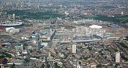 Aerial view of Stratford City in June 2011 | |
 Stratford City Stratford City shown within Greater London | |
| OS grid reference | TQ385845 |
| • Charing Cross | 6 mi (9.7 km) WSW |
| London borough | |
| Ceremonial county | Greater London |
| Region | |
| Country | England |
| Sovereign state | United Kingdom |
| Post town | LONDON |
| Postcode district | E20 |
| Dialling code | 020 |
| Police | Metropolitan |
| Fire | London |
| Ambulance | London |
| EU Parliament | London |
| UK Parliament | |
| London Assembly | |
Stratford City is a mixed-use development project in Stratford, London, England. The main developers are the Westfield Group and Lend Lease.
Stratford City is the name given to the urban community centred on the Queen Elizabeth Olympic Park. Based on Stratford Regional and Stratford International railway stations, it includes "The International Quarter", a joint venture between Lend Lease and London and Continental Railways (LCR) to create a £2 billion commercial and residential development, the Westfield shopping centre, Chobham Academy, and the East Village, previously the athletes’ village constructed by Lend Lease for the London 2012 Olympic and Paralympic Games.
Within Stratford City there is provision for 2,900,000-square-foot (270,000 m2) of retail and leisure space, 1,300,000-square-foot (120,000 m2) of hotel space, 6,600,000-square-foot (610,000 m2) of commercial district space, 16,400 new homes, 180,000-square-foot (17,000 m2) of community facilities, and two energy centres capable of providing 75% of the sites' energy needs. Royal Mail has allocated the postcode E20 to Stratford City and the Queen Elizabeth Olympic Park.
Planning
The whole Queen Elizabeth II Olympic Park site was proposed to be secured under a compulsory purchase order (CPO) by the London Development Agency. In late 2005, a row broke out between then Mayor of London Ken Livingstone and Newham Council/Westfield over the use of the legal instrument. The site for the Olympic Village was to be located next to the £4 billion development of Stratford City, but access difficulties meant that the Olympic Park CPO extended onto the site for Stratford City. In November 2005, an agreement was made where by the CPO over the Westfield site was removed, subject to agreed access provisions to the Olympic Village.[1]
The Olympic Village, home of the athletes during the 2012 Summer Games and constructed by Lend Lease, would be redeveloped at the new East Village urban development as part of the legacy project.
Construction
Work started in early 2007, and the entire project was completed in 2012.[2] Work was carried out in phases, with Phase 1 completed in 2011. Phase 1 includes 1.9 million ft² (150,000 m²) of retail and leisure space (see Westfield Stratford City), a 267-room Premier Inn hotel,[3] 1.1m sq ft of office space, and 4,850 new homes. The office space comprises a cluster of four tall office buildings: Stratford Place, at 130,000 sq ft; The Square, at 200,000 sq ft; First Avenue, at over 560,000 sq ft; and Station Square, at 95,000 sq ft.
Transport
The site is adjacent to both the existing Stratford Regional station and the new Stratford International station. Stratford Regional station is served by London Overground, Docklands Light Railway, TfL Rail, London Underground and National Rail services,[4] with Crossrail services planned to serve the station from 2018.[5] Stratford International station is served by Southeastern domestic services on High Speed 1[6] and Docklands Light Railway services to London City Airport, Beckton and Woolwich Arsenal. Currently no international services call, although Eurostar will review stopping after the Olympic Games.[7] A pedestrian bridge connects the development to the existing Stratford town centre.
References
- ↑ "Deal settles 2012 site land row". BBC News. 21 November 2005. Retrieved 27 July 2012.
- ↑ "Stratford City: A new metropolitan centre for East London". Archived from the original on 6 May 2014. Retrieved 1 September 2014.
- ↑ "New Premier Inn adjacent to the Olympic Stadium". Premierinn.com. 19 July 2012. Retrieved 27 July 2012.
- ↑ "Oyster Tube Map – Stratford Regional station appears simply as "Stratford"" (PDF). Transport for London.
- ↑ "Crossrail". Crossrail. Retrieved 27 July 2012.
- ↑ "Southeastern network map". Southeastern.
- ↑ "Eurostar 'will not stop' at Stratford International". BBC News. 25 May 2010.
External links
| Wikimedia Commons has media related to Stratford City. |
| Districts | 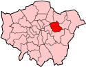 | |
|---|---|---|
| Attractions | ||
| Sports | ||
| Markets | ||
| Parks and open spaces |
| |
| Constituencies | ||
| Tube, rail and DLR stations |
| |
| Other topics | ||