Stražica Lighthouse
 Stražica lighthouse in 1990 | |
 Stražica Lighthouse | |
| Location | Prvić, Croatia |
|---|---|
| Coordinates | 44°56′00″N 14°46′05″E / 44.93324°N 14.76816°ECoordinates: 44°56′00″N 14°46′05″E / 44.93324°N 14.76816°E |
| Year first constructed | 1875 |
| Automated |
1974 |
| Tower shape | Square tower on roof of dwelling |
| Height | 5 metres (16 ft) |
| Focal height | 21 metres (69 ft) |
| Range | 9 nautical miles (17 km; 10 mi) |
| Characteristic |
FI W 6s |
| Admiralty number | E2887 |
| NGA number | 12460 |
| ARLHS number | CRO-147 |
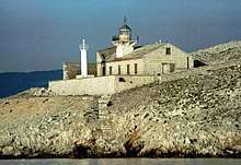
Stražica Lighthouse on the island of Prvić in the Adriatic Sea was built in 1875 and consists of a small stone house and a 5-metre (16 ft) tall lighthouse tower.[1] A crew of lightkeepers were stationed on the island until it was made fully automated in 1974. In 1993 the natural gas-powered system was replaced with solar panels and is today remotely controlled by Plovput, the state-owned company for maritime traffic which controls the entire network of Croatian lighthouses. Until 1974, the lighthouse crew were the only inhabitants of Prvić,[2] and until the early 2000s it was believed that Prvić held the distinction of being the largest uninhabited Croatian island,[3] but this was refuted when new measurements published in 2004 showed that the island of Žut is bigger by some 2 square kilometres (0.77 sq mi).[4] In September 2009 the Croatian Post included the Stražica lighthouse in their lighthouse-themed series of stamps.[5]
See also
Notes
- ↑ "Svjetionik Rt Stražica" (in Croatian). Plovput.hr. Archived from the original on 1 February 2014. Retrieved 10 June 2010.
- ↑ Trinajstić, Mladen. "Svjetionik, nijemi svjedok nebrige". Novi list (in Croatian). Retrieved 10 June 2010.
- ↑ Rac, Krunoslav (September 2007). "Otok Prvić" (PDF). Eco Review (in Croatian). Environmental Protection and Energy Efficiency Fund. p. 76. Archived from the original (PDF) on 5 February 2011. Retrieved 12 June 2010.
- ↑ Hydrographic Institute of the Republic of Croatia (2004). "Coastline lengths and areas of islands in the Croatian part of the Adriatic Sea determined from the topographic maps at the scale 1:25,000" (PDF). Geoadria. p. 12. Retrieved 10 June 2010.
- ↑ "Marka br. 738, Svjetionici - Stražica" (in Croatian). Croatian Post. Archived from the original on 21 February 2011. Retrieved 10 June 2010.