Stokeleigh Camp
| Stokeleigh Camp | |
|---|---|
 | |
| Location | Leigh Woods, North Somerset, England |
| Coordinates | 51°27′25″N 2°38′15″W / 51.45694°N 2.63750°WCoordinates: 51°27′25″N 2°38′15″W / 51.45694°N 2.63750°W |
| Area | 7.5 acres (3.0 ha) |
| Built | Iron Age |
| Reference no. | 198375[1] |
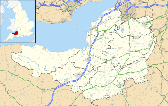 Location of Stokeleigh Camp in Somerset | |
Stokeleigh Camp is an Iron Age promontory fort in Leigh Woods North Somerset near Bristol, England. It has been designated a Scheduled Ancient Monument.[2]
Background
Hill forts developed in the Late Bronze and Early Iron Age, roughly the start of the first millennium BC.[3] The reason for their emergence in Britain, and their purpose, has been a subject of debate. It has been argued that they could have been military sites constructed in response to invasion from continental Europe, sites built by invaders themselves, or a military reaction to social tensions caused by an increasing population and consequent pressure on agriculture. The dominant view since the 1960s has been that the increasing use of iron led to social changes in Britain. Deposits of iron ore were located in different places to the tin and copper ore necessary to make bronze, and as a result trading patterns shifted and the old elites lost their economic and social status, as iron made edged weapons more generally available.[4] Power passed into the hands of a new group of people.[5] Archaeologist Barry Cunliffe believes that population increase still played a role and has stated "[the forts] provided defensive possibilities for the community at those times when the stress [of an increasing population] burst out into open warfare. But I wouldn't see them as having been built because there was a state of war. They would be functional as defensive strongholds when there were tensions and undoubtedly some of them were attacked and destroyed, but this was not the only, or even the most significant, factor in their construction".[6]
Situation
Stokeleigh Camp is one of three Iron Age fortifications overlooking the Avon Gorge, the others being Burwalls south of the Nightingale Valley, of which almost no trace remains, and the other being Clifton Camp on the opposite side of the gorge, on Clifton Down near the Observatory.[7]
A prehistoric road ran from Stokeleigh Camp to Cadbury Camp near Tickenham.[8]
Description
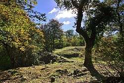
Stokeleigh Camp is situated on a promontory,[9] and occupies around 7.5 acres (3.0 ha).[1][7] It was protected by the Avon Gorge to the north and east, by the steeply sloping Nightingale Valley on the south and by three ramparts which increase in size as they move inwards towards the central plateau, with the innermost vallum (a ditch and rampart with a palisade) being over 30 feet (9.1 m) high.[10][11] It shows evidence of dry walling along most of its length,[1] although this may not be an original feature.[7]
History
Stokeleigh Camp is thought to have been occupied from the late pre-Roman Iron Age, when it was in the area controlled by the Dobunni.[12] Archaeological investigations suggest during the 1st century Belgae tribes may have been present with some of the pottery showing the influence of the Durotriges. There may have been a break in occupation before reuse in the middle to late 2nd century.[1]
In addition to the pottery recovered a possible coin of Gallienus dating from his reign between 253 and 268 has been recovered. An iron-involuted brooch of the La Tène II type has also been found.[1]
It is unclear whether the occupation of Stokeleigh Camp in the 3rd century was for a formal garrison or whether it was just used by "squatters" or as a place of refuge in times of crisis. It has been suggested that Stokeleigh was connected with the Wansdyke, a series of defensive linear earthworks, consisting of a ditch and an embankment running at least from Maes Knoll in Somerset, to the Savernake Forest near Marlborough in Wiltshire, however there is little evidence for this.[7]
It is also possible that the site was occupied in the Middle Ages.[2]
See also
References
- 1 2 3 4 5 Historic England. "Stokeleigh Camp (198375)". PastScape. Retrieved 30 January 2011.
- 1 2 "Where I Live: Bristol". British Broadcasting Corporation. October 2004. Retrieved 26 December 2010.
- ↑ Payne, Andrew; Corney, Mark; Cunliffe, Barry (2007), The Wessex Hillforts Project: Extensive Survey of Hillfort Interiors in Central Southern England, English Heritage, p. 1, ISBN 978-1-873592-85-4
- ↑ Leonard R. Palmer has suggested that iron, whilst inferior to bronze weapons, was in more plentiful supply and so, taking his examples from the Aegean basin, allowed larger fighting bands armed with iron to overwhelm the smaller bronze-armed elites; see Leonard R. Palmer (1962) Mycenaeans and Minoans: Aegean Prehistory in the Light of the Linear B Tablets. (New York, Alfred A. Knopf, 1962)
- ↑ Sharples, Niall M (1991), English Heritage Book of Maiden Castle, London: B. T. Batsford, pp. 71–72, ISBN 0-7134-6083-0
- ↑ Time Team: Swords, skulls and strongholds, Channel 4, 2008-05-19, retrieved 16 September 2009
- 1 2 3 4 Bain, Nigel B. (2009). "Stokeleigh Camp". villages of Wraxall and Failand. Retrieved 29 January 2011.
- ↑ Page, William (1906). "Early Man". A History of the County of Somerset: Volume 1. British History Online. Retrieved 30 January 2011.
- ↑ "Stokeleigh Camp Hillfort". Hillfort in England in Somerset. Megalithic Portal. Retrieved 26 December 2010.
- ↑ "Stokeleigh Camp". Roman Britain. Archived from the original on 3 July 2011. Retrieved 29 January 2011.
- ↑ Haldane, J.W. (1966). "Stokeleigh Camp, Somerset" (PDF). Proceedings of the University of Bristol Spelæological Society. Bristol: University of Bristol Spelæological Society. 11 (1): 31–38. Retrieved 30 January 2011.
- ↑ "Stokeleigh Camp". English Heritage. Retrieved 30 January 2011.