Stickleyville, Virginia
| Stickleyville, Virginia | |
|---|---|
| Unincorporated community | |
 Stickleyville | |
 Stickleyville, Virginia  Stickleyville, Virginia | |
| Coordinates: 36°42′25″N 82°54′26″W / 36.70694°N 82.90722°WCoordinates: 36°42′25″N 82°54′26″W / 36.70694°N 82.90722°W | |
| Country | United States |
| State | Virginia |
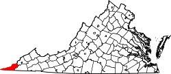
| County | Lee |
| Elevation | 1,631 ft (497 m) |
| Time zone | UTC−5 (Eastern (EST)) |
| • Summer (DST) | UTC−4 (EDT) |
| GNIS feature ID | 1475137[1] |
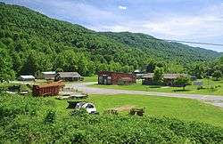
Stickleyville is an unincorporated community in Lee County, Virginia, United States. It was also known as Stickleysville. The community is concentrated along U.S. Route 421 near the Lee County/Scott County line in the Wallen Creek Valley. Duffield lies across Powell Mountain to the east, and Pennington Gap lies across Wallen Ridge to the northwest.
A post office was established as Stickleysville in 1850.[2] The community was named for Vastine Stickley, a pioneer settler.[3]
References
- ↑ U.S. Geological Survey Geographic Names Information System: Stickleyville, Virginia
- ↑ "Lee County". Jim Forte Postal History. Retrieved 30 September 2014.
- ↑ Tennis, Joe (2004). Southwest Virginia Crossroads: An Almanac of Place Names and Places to See. The Overmountain Press. p. 17. ISBN 978-1-57072-256-1.
This article is issued from
Wikipedia.
The text is licensed under Creative Commons - Attribution - Sharealike.
Additional terms may apply for the media files.